Earlville elevation
Earlville (Illinois, LaSalle County), United States elevation is 215 meters and Earlville elevation in feet is 705 ft above sea level [src 1]. Earlville is a populated place (feature code) with elevation that is 64 meters (210 ft) smaller than average city elevation in United States.
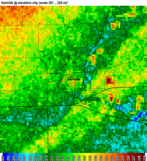
Below is the Elevation map of Earlville, which displays elevation range with different colors. Scale of the first map is from 201 to 229 m (659 to 751 ft) with average elevation of 213.3 meters (=700 ft) [note 1]
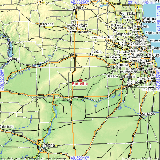
These maps also provides idea of topography and contour of this city, they are displayed at different zoom levels. More info about maps, scale and edge coordinates you can find below images.
| \ | Map #1 | Topo.Map |
| Scale [m] | 201..229 m | × |
| Scale [ft] | 659..751 ft | × |
| Average | 213.3 m = 700 ft | × |
| Width | 7.31 km = 4.5 mi | 233.9 km = 145.3 mi |
| Height | 7.31 km = 4.5 mi | 233.9 km = 145.3 mi |
| ↑Max Latitude | 41.622339° | 42.63266° |
| Latitude at center | 41.58948° | 41.58948° |
| ↓Min Latitude | 41.556604° | 40.52916° |
| ← Min Longitude | -88.965975° | -90.32828° |
| Longitude center | -88.92203° | -88.92203° |
| →Max Longitude | -88.878085° | -87.51578° |
Nearby cities:
Cities around Earlville sort by population:
• Ottawa elevation 150 m
27.9 km,  166°
166°
• Plano 199 m
33 km,  75°
75°
• La Salle 175 m
31.8 km,  206°
206°
• Sandwich 203 m
25.7 km, 75°
• Mendota 229 m
16.9 km,  253°
253°
• Marseilles 161 m
33.8 km,  148°
148°
• Lake Holiday 211 m
20.9 km, 82°
• Sheridan 182 m
21.2 km,  108°
108°
• Hinckley 229 m
30.7 km,  49°
49°
• Somonauk 212 m
20.6 km, 76°
• Waterman 256 m
23.7 km,  31°
31°
• Newark 207 m
28.8 km,  101°
101°
Multilingual:
 En español:
Earlville elevación 215 m.
 En France:
Earlville élévation 215 m.
 Auf Deutsch:
Earlville höhe über dem Meeresspiegel ist 215 m.

Sources and notes:
- [note 1] Map square and city borders are not equal. Map elevation data is calculated only from area inside that square.
- [src 1] Elevation data from geonames database provided with same terms of usage.
- [src 2] The elevation map of Earlville is generated using elevation data from NASA's 3 arcsec (90m) resolution SRTM data.
- [src 3] Base (background) map © OpenStreetMap contributors tiles are generated by Geofabrik and OpenTopoMap.
Copyright & License:
This Earlville Elevation Map is licensed under CC BY-SA. You may reuse any part from this page, if you give a proper credit by linking to this URL:
 More info on terms of use page.