Plano elevation
Plano (Illinois, Kendall County), United States elevation is 199 meters and Plano elevation in feet is 653 ft above sea level [src 1]. Plano is a populated place (feature code) with elevation that is 80 meters (262 ft) smaller than average city elevation in United States.
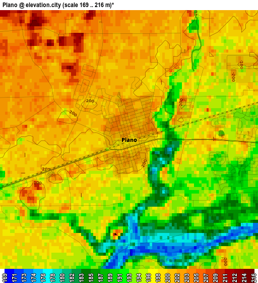
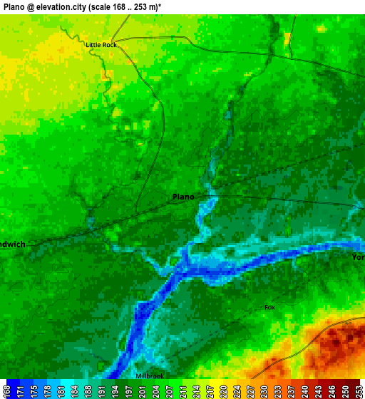
Below is the Elevation map of Plano, which displays elevation range with different colors. Scale of the first map is from 169 to 216 m (554 to 709 ft) with average elevation of 196.6 meters (=645 ft) [note 1]
These maps also provides idea of topography and contour of this city, they are displayed at different zoom levels. More info about maps, scale and edge coordinates you can find below images.
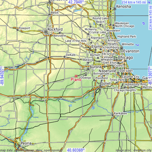
| \ | Map #1 | Map #2 | Topo.Map |
| Scale [m] | 169..216 m | 168..253 m | × |
| Scale [ft] | 554..709 ft | 551..830 ft | × |
| Average | 196.6 m = 645 ft | 202 m = 663 ft | × |
| Width | 7.3 km = 4.5 mi | 14.6 km = 9.1 mi | 233.6 km = 145.2 mi |
| Height | 7.3 km = 4.5 mi | 14.6 km = 9.1 mi | 233.6 km = 145.2 mi |
| ↑Max Latitude | 41.695632° | 41.728437° | 42.7048° |
| Latitude at center | 41.66281° | 41.66281° | 41.66281° |
| ↓Min Latitude | 41.629971° | 41.597116° | 40.60369° |
| ← Min Longitude | -88.580965° | -88.624911° | -89.94327° |
| Longitude center | -88.53702° | -88.53702° | -88.53702° |
| →Max Longitude | -88.493075° | -88.449129° | -87.13077° |
Nearby cities:
Cities around Plano sort by population:
• Oswego elevation 196 m
15.6 km,  81°
81°
• Montgomery 194 m
17.6 km,  64°
64°
• Yorkville 191 m
7.8 km,  107°
107°
• Sugar Grove 220 m
13.4 km,  35°
35°
• Lynwood 198 m
12.1 km, 78°
• Sandwich 203 m
7.3 km,  255°
255°
• Lake Holiday 211 m
12.5 km,  243°
243°
• Hinckley 229 m
14.6 km,  323°
323°
• Somonauk 212 m
12.4 km,  254°
254°
• Prestbury 212 m
16.7 km, 36°
• Big Rock 217 m
11.3 km,  355°
355°
• Newark 207 m
14.5 km,  195°
195°
Multilingual:
 En español:
Plano elevación 199 m.
 En France:
Plano élévation 199 m.


Sources and notes:
- [note 1] Map square and city borders are not equal. Map elevation data is calculated only from area inside that square.
- [src 1] Elevation data from geonames database provided with same terms of usage.
- [src 2] The elevation map of Plano is generated using elevation data from NASA's 3 arcsec (90m) resolution SRTM data.
- [src 3] Base (background) map © OpenStreetMap contributors tiles are generated by Geofabrik and OpenTopoMap.
Copyright & License:
This Plano Elevation Map is licensed under CC BY-SA. You may reuse any part from this page, if you give a proper credit by linking to this URL:
 More info on terms of use page.