Montezuma elevation
Montezuma (Iowa, Poweshiek County), United States elevation is 290 meters and Montezuma elevation in feet is 951 ft above sea level [src 1]. Montezuma is a seat of a second-order administrative division (feature code) with elevation that is 11 meters (36 ft) bigger than average city elevation in United States.
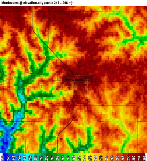
Below is the Elevation map of Montezuma, which displays elevation range with different colors. Scale of the first map is from 241 to 296 m (791 to 971 ft) with average elevation of 280.9 meters (=922 ft) [note 1]
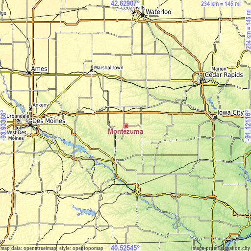
These maps also provides idea of topography and contour of this city, they are displayed at different zoom levels. More info about maps, scale and edge coordinates you can find below images.
| \ | Map #1 | Topo.Map |
| Scale [m] | 241..296 m | × |
| Scale [ft] | 791..971 ft | × |
| Average | 280.9 m = 922 ft | × |
| Width | 7.31 km = 4.5 mi | 233.9 km = 145.3 mi |
| Height | 7.31 km = 4.5 mi | 233.9 km = 145.3 mi |
| ↑Max Latitude | 41.618691° | 42.62907° |
| Latitude at center | 41.58583° | 41.58583° |
| ↓Min Latitude | 41.552952° | 40.52545° |
| ← Min Longitude | -92.571355° | -93.93366° |
| Longitude center | -92.52741° | -92.52741° |
| →Max Longitude | -92.483465° | -91.12116° |
Nearby cities:
Cities around Montezuma sort by population:
• Newton elevation 290 m
45.1 km,  286°
286°
• Oskaloosa 256 m
33.6 km,  196°
196°
• Pella 273 m
37.9 km,  238°
238°
• Grinnell 309 m
23.8 km,  317°
317°
• Williamsburg 251 m
43.9 km,  79°
79°
• Tama 258 m
42.5 km,  354°
354°
• Marengo 228 m
44.7 km,  58°
58°
• Belle Plaine 251 m
40.3 km,  30°
30°
• Sigourney 243 m
38.9 km,  136°
136°
• Brooklyn 279 m
17.8 km,  22°
22°
• New Sharon 269 m
16.5 km,  218°
218°
• North English 249 m
38.4 km,  102°
102°
Multilingual:
 En español:
Montezuma elevación 290 m.
 En France:
Montezuma élévation 290 m.
 Auf Deutsch:
Montezuma höhe über dem Meeresspiegel ist 290 m.

Sources and notes:
- [note 1] Map square and city borders are not equal. Map elevation data is calculated only from area inside that square.
- [src 1] Elevation data from geonames database provided with same terms of usage.
- [src 2] The elevation map of Montezuma is generated using elevation data from NASA's 3 arcsec (90m) resolution SRTM data.
- [src 3] Base (background) map © OpenStreetMap contributors tiles are generated by Geofabrik and OpenTopoMap.
Copyright & License:
This Montezuma Elevation Map is licensed under CC BY-SA. You may reuse any part from this page, if you give a proper credit by linking to this URL:
 More info on terms of use page.