Belle Plaine elevation
Belle Plaine (Iowa, Benton County), United States elevation is 251 meters and Belle Plaine elevation in feet is 823 ft above sea level [src 1]. Belle Plaine is a populated place (feature code) with elevation that is 28 meters (92 ft) smaller than average city elevation in United States.
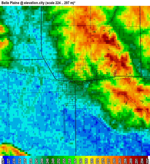
Below is the Elevation map of Belle Plaine, which displays elevation range with different colors. Scale of the first map is from 224 to 297 m (735 to 974 ft) with average elevation of 249.4 meters (=818 ft) [note 1]
These maps also provides idea of topography and contour of this city, they are displayed at different zoom levels. More info about maps, scale and edge coordinates you can find below images.
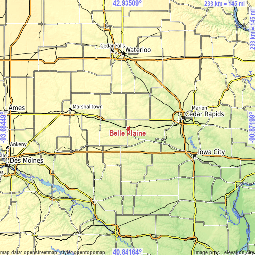
| \ | Map #1 | Topo.Map |
| Scale [m] | 224..297 m | × |
| Scale [ft] | 735..974 ft | × |
| Average | 249.4 m = 818 ft | × |
| Width | 7.27 km = 4.5 mi | 232.8 km = 144.7 mi |
| Height | 7.27 km = 4.5 mi | 232.8 km = 144.7 mi |
| ↑Max Latitude | 41.929642° | 42.93509° |
| Latitude at center | 41.89694° | 41.89694° |
| ↓Min Latitude | 41.864221° | 40.84164° |
| ← Min Longitude | -92.322185° | -93.68449° |
| Longitude center | -92.27824° | -92.27824° |
| →Max Longitude | -92.234295° | -90.87199° |
Nearby cities:
Cities around Belle Plaine sort by population:
• Grinnell elevation 309 m
40.6 km,  245°
245°
• Vinton 243 m
36.8 km,  34°
34°
• Williamsburg 251 m
34.4 km,  139°
139°
• Tama 258 m
25.9 km,  287°
287°
• Marengo 228 m
20.4 km,  122°
122°
• Toledo 276 m
27 km, 293°
• Atkins 262 m
36.2 km,  72°
72°
• Traer 277 m
36.4 km,  334°
334°
• Walford 245 m
36.8 km,  93°
93°
• Brooklyn 279 m
22.8 km,  217°
217°
• Montezuma 290 m
40.3 km,  210°
210°
• Dysart 295 m
30.6 km,  355°
355°
Multilingual:
 En español:
Belle Plaine elevación 251 m.
 En France:
Belle Plaine élévation 251 m.
 Auf Deutsch:
Belle Plaine höhe über dem Meeresspiegel ist 251 m.

Sources and notes:
- [note 1] Map square and city borders are not equal. Map elevation data is calculated only from area inside that square.
- [src 1] Elevation data from geonames database provided with same terms of usage.
- [src 2] The elevation map of Belle Plaine is generated using elevation data from NASA's 3 arcsec (90m) resolution SRTM data.
- [src 3] Base (background) map © OpenStreetMap contributors tiles are generated by Geofabrik and OpenTopoMap.
Copyright & License:
This Belle Plaine Elevation Map is licensed under CC BY-SA. You may reuse any part from this page, if you give a proper credit by linking to this URL:
 More info on terms of use page.