Marengo elevation
Marengo (Iowa, Iowa County), United States elevation is 228 meters and Marengo elevation in feet is 748 ft above sea level [src 1]. Marengo is a seat of a second-order administrative division (feature code) with elevation that is 51 meters (167 ft) smaller than average city elevation in United States.
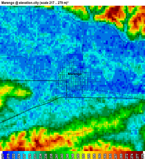
Below is the Elevation map of Marengo, which displays elevation range with different colors. Scale of the first map is from 217 to 279 m (712 to 915 ft) with average elevation of 232.8 meters (=764 ft) [note 1]
These maps also provides idea of topography and contour of this city, they are displayed at different zoom levels. More info about maps, scale and edge coordinates you can find below images.
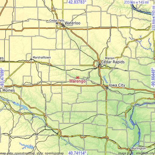
| \ | Map #1 | Topo.Map |
| Scale [m] | 217..279 m | × |
| Scale [ft] | 712..915 ft | × |
| Average | 232.8 m = 764 ft | × |
| Width | 7.29 km = 4.5 mi | 233.1 km = 144.8 mi |
| Height | 7.29 km = 4.5 mi | 233.1 km = 144.8 mi |
| ↑Max Latitude | 41.830813° | 42.83783° |
| Latitude at center | 41.79806° | 41.79806° |
| ↓Min Latitude | 41.76529° | 40.74114° |
| ← Min Longitude | -92.114685° | -93.47699° |
| Longitude center | -92.07074° | -92.07074° |
| →Max Longitude | -92.026795° | -90.66449° |
Nearby cities:
Cities around Marengo sort by population:
• North Liberty elevation 236 m
39.6 km,  97°
97°
• Vinton 243 m
41.4 km,  5°
5°
• Williamsburg 251 m
16.1 km,  161°
161°
• Tiffin 218 m
35.3 km,  106°
106°
• Fairfax 235 m
27.5 km,  60°
60°
• Belle Plaine 251 m
20.4 km,  302°
302°
• Ely 225 m
41.1 km,  78°
78°
• Atkins 262 m
28.1 km,  37°
37°
• Walford 245 m
21.5 km,  65°
65°
• Brooklyn 279 m
31.9 km,  257°
257°
• Palo 229 m
37.5 km, 37°
• North English 249 m
31.6 km,  180°
180°
Multilingual:
 En español:
Marengo elevación 228 m.
 En France:
Marengo élévation 228 m.


Sources and notes:
- [note 1] Map square and city borders are not equal. Map elevation data is calculated only from area inside that square.
- [src 1] Elevation data from geonames database provided with same terms of usage.
- [src 2] The elevation map of Marengo is generated using elevation data from NASA's 3 arcsec (90m) resolution SRTM data.
- [src 3] Base (background) map © OpenStreetMap contributors tiles are generated by Geofabrik and OpenTopoMap.
Copyright & License:
This Marengo Elevation Map is licensed under CC BY-SA. You may reuse any part from this page, if you give a proper credit by linking to this URL:
 More info on terms of use page.