Traer elevation
Traer (Iowa, Tama County), United States elevation is 277 meters and Traer elevation in feet is 909 ft above sea level [src 1]. Traer is a populated place (feature code) with elevation that is 2 meters (7 ft) smaller than average city elevation in United States.
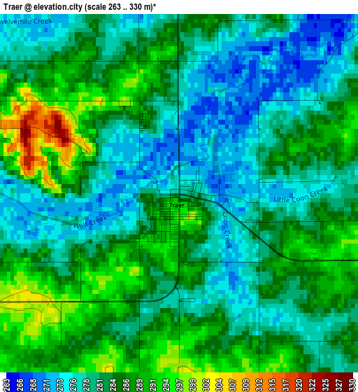
Below is the Elevation map of Traer, which displays elevation range with different colors. Scale of the first map is from 263 to 330 m (863 to 1083 ft) with average elevation of 283 meters (=928 ft) [note 1]
These maps also provides idea of topography and contour of this city, they are displayed at different zoom levels. More info about maps, scale and edge coordinates you can find below images.
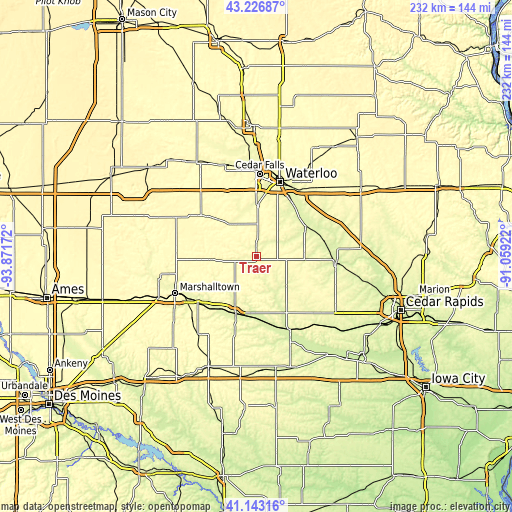
| \ | Map #1 | Topo.Map |
| Scale [m] | 263..330 m | × |
| Scale [ft] | 863..1083 ft | × |
| Average | 283 m = 928 ft | × |
| Width | 7.24 km = 4.5 mi | 231.7 km = 144 mi |
| Height | 7.24 km = 4.5 mi | 231.7 km = 144 mi |
| ↑Max Latitude | 42.22615° | 43.22687° |
| Latitude at center | 42.1936° | 42.1936° |
| ↓Min Latitude | 42.161033° | 41.14316° |
| ← Min Longitude | -92.509415° | -93.87172° |
| Longitude center | -92.46547° | -92.46547° |
| →Max Longitude | -92.421525° | -91.05922° |
Nearby cities:
Cities around Traer sort by population:
• Waterloo elevation 263 m
34.8 km,  16°
16°
• Evansdale 260 m
34.2 km,  26°
26°
• Tama 258 m
26.9 km,  200°
200°
• Grundy Center 314 m
31.2 km,  306°
306°
• Hudson 275 m
23.7 km,  1°
1°
• La Porte City 253 m
26.2 km,  59°
59°
• Toledo 276 m
23.9 km, 202°
• Reinbeck 293 m
18.2 km,  322°
322°
• Dysart 295 m
13.3 km,  100°
100°
• Dike 290 m
32.9 km,  336°
336°
• Elk Run Heights 260 m
34.9 km, 29°
• Conrad 308 m
33.9 km,  275°
275°
Multilingual:
 En español:
Traer elevación 277 m.
 En France:
Traer élévation 277 m.


Sources and notes:
- [note 1] Map square and city borders are not equal. Map elevation data is calculated only from area inside that square.
- [src 1] Elevation data from geonames database provided with same terms of usage.
- [src 2] The elevation map of Traer is generated using elevation data from NASA's 3 arcsec (90m) resolution SRTM data.
- [src 3] Base (background) map © OpenStreetMap contributors tiles are generated by Geofabrik and OpenTopoMap.
Copyright & License:
This Traer Elevation Map is licensed under CC BY-SA. You may reuse any part from this page, if you give a proper credit by linking to this URL:
 More info on terms of use page.