Ashville elevation
Ashville (Alabama, Saint Clair County), United States elevation is 173 meters and Ashville elevation in feet is 568 ft above sea level [src 1]. Ashville is a populated place (feature code) with elevation that is 106 meters (348 ft) smaller than average city elevation in United States.
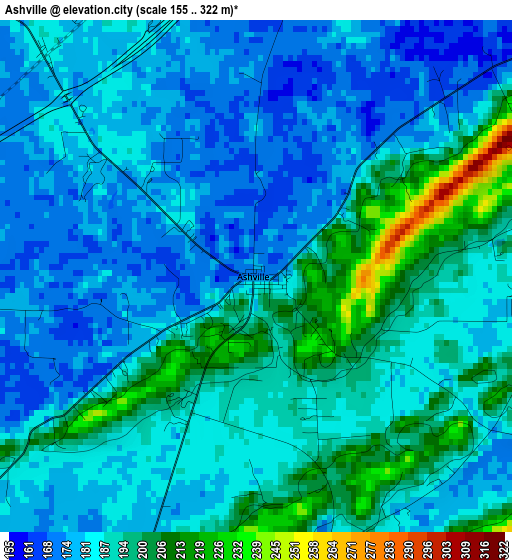
Below is the Elevation map of Ashville, which displays elevation range with different colors. Scale of the first map is from 155 to 322 m (509 to 1056 ft) with average elevation of 186.7 meters (=613 ft) [note 1]
These maps also provides idea of topography and contour of this city, they are displayed at different zoom levels. More info about maps, scale and edge coordinates you can find below images.
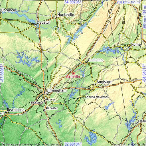
| \ | Map #1 | Topo.Map |
| Scale [m] | 155..322 m | × |
| Scale [ft] | 509..1056 ft | × |
| Average | 186.7 m = 613 ft | × |
| Width | 8.12 km = 5 mi | 259.7 km = 161.4 mi |
| Height | 8.12 km = 5 mi | 259.7 km = 161.4 mi |
| ↑Max Latitude | 33.873534° | 34.99708° |
| Latitude at center | 33.83704° | 33.83704° |
| ↓Min Latitude | 33.80053° | 32.66104° |
| ← Min Longitude | -86.298365° | -87.66067° |
| Longitude center | -86.25442° | -86.25442° |
| →Max Longitude | -86.210475° | -84.84817° |
Nearby cities:
Cities around Ashville sort by population:
• Rainbow City elevation 170 m
23.6 km,  56°
56°
• Southside 193 m
23.5 km,  65°
65°
• Oneonta 260 m
23.6 km,  301°
301°
• Lincoln 153 m
27.9 km,  153°
153°
• Attalla 165 m
25.6 km,  36°
36°
• Margaret 210 m
26.4 km,  230°
230°
• Springville 220 m
21.2 km,  251°
251°
• Odenville 226 m
22.1 km,  216°
216°
• Riverside 146 m
26.1 km,  169°
169°
• Ragland 172 m
13.7 km,  138°
138°
• Ohatchee 158 m
24 km,  104°
104°
• Steele 178 m
12.4 km,  23°
23°
Multilingual:
 En español:
Ashville elevación 173 m.
 En France:
Ashville élévation 173 m.
 Auf Deutsch:
Ashville höhe über dem Meeresspiegel ist 173 m.

Sources and notes:
- [note 1] Map square and city borders are not equal. Map elevation data is calculated only from area inside that square.
- [src 1] Elevation data from geonames database provided with same terms of usage.
- [src 2] The elevation map of Ashville is generated using elevation data from NASA's 3 arcsec (90m) resolution SRTM data.
- [src 3] Base (background) map © OpenStreetMap contributors tiles are generated by Geofabrik and OpenTopoMap.
Copyright & License:
This Ashville Elevation Map is licensed under CC BY-SA. You may reuse any part from this page, if you give a proper credit by linking to this URL:
 More info on terms of use page.