Oneonta elevation
Oneonta (Alabama, Blount County), United States elevation is 260 meters and Oneonta elevation in feet is 853 ft above sea level [src 1]. Oneonta is a seat of a second-order administrative division (feature code) with elevation that is 19 meters (62 ft) smaller than average city elevation in United States.
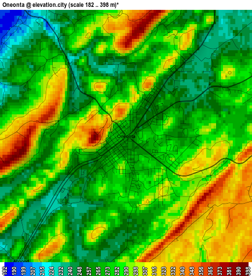
Below is the Elevation map of Oneonta, which displays elevation range with different colors. Scale of the first map is from 182 to 398 m (597 to 1306 ft) with average elevation of 280.8 meters (=921 ft) [note 1]
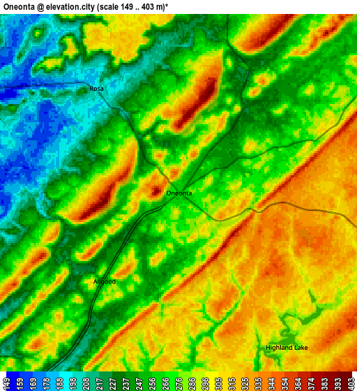
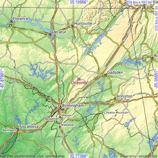
These maps also provides idea of topography and contour of this city, they are displayed at different zoom levels. More info about maps, scale and edge coordinates you can find below images.
| \ | Map #1 | Map #2 | Topo.Map |
| Scale [m] | 182..398 m | 149..403 m | × |
| Scale [ft] | 597..1306 ft | 489..1322 ft | × |
| Average | 280.8 m = 921 ft | 273.2 m = 896 ft | × |
| Width | 8.11 km = 5 mi | 16.21 km = 10.1 mi | 259.4 km = 161.2 mi |
| Height | 8.11 km = 5 mi | 16.21 km = 10.1 mi | 259.4 km = 161.2 mi |
| ↑Max Latitude | 33.984597° | 34.021028° | 35.10666° |
| Latitude at center | 33.94815° | 33.94815° | 33.94815° |
| ↓Min Latitude | 33.911688° | 33.87521° | 32.77366° |
| ← Min Longitude | -86.516705° | -86.560651° | -87.87901° |
| Longitude center | -86.47276° | -86.47276° | -86.47276° |
| →Max Longitude | -86.428815° | -86.384869° | -85.06651° |
Nearby cities:
Cities around Oneonta sort by population:
• Dixiana elevation 227 m
28.3 km,  215°
215°
• Clay 291 m
29.7 km,  203°
203°
• Margaret 210 m
29.1 km,  180°
180°
• Springville 220 m
19.2 km, 179°
• Argo 276 m
29.1 km,  185°
185°
• Hanceville 168 m
29.9 km,  294°
294°
• Ashville 173 m
23.6 km,  121°
121°
• Blountsville 220 m
18.4 km,  323°
323°
• Hayden 171 m
27 km,  256°
256°
• Cleveland 164 m
10.8 km,  296°
296°
• Locust Fork 178 m
13.9 km,  251°
251°
• Steele 178 m
25 km,  92°
92°
Multilingual:
 En español:
Oneonta elevación 260 m.
 En France:
Oneonta élévation 260 m.


Sources and notes:
- [note 1] Map square and city borders are not equal. Map elevation data is calculated only from area inside that square.
- [src 1] Elevation data from geonames database provided with same terms of usage.
- [src 2] The elevation map of Oneonta is generated using elevation data from NASA's 3 arcsec (90m) resolution SRTM data.
- [src 3] Base (background) map © OpenStreetMap contributors tiles are generated by Geofabrik and OpenTopoMap.
Copyright & License:
This Oneonta Elevation Map is licensed under CC BY-SA. You may reuse any part from this page, if you give a proper credit by linking to this URL:
 More info on terms of use page.