Hanceville elevation
Hanceville (Alabama, Cullman County), United States elevation is 168 meters and Hanceville elevation in feet is 551 ft above sea level [src 1]. Hanceville is a populated place (feature code) with elevation that is 111 meters (364 ft) smaller than average city elevation in United States.
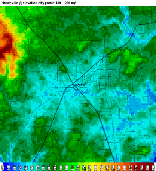
Below is the Elevation map of Hanceville, which displays elevation range with different colors. Scale of the first map is from 139 to 296 m (456 to 971 ft) with average elevation of 185.2 meters (=608 ft) [note 1]
These maps also provides idea of topography and contour of this city, they are displayed at different zoom levels. More info about maps, scale and edge coordinates you can find below images.
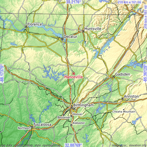
| \ | Map #1 | Topo.Map |
| Scale [m] | 139..296 m | × |
| Scale [ft] | 456..971 ft | × |
| Average | 185.2 m = 608 ft | × |
| Width | 8.1 km = 5 mi | 259.1 km = 161 mi |
| Height | 8.1 km = 5 mi | 259.1 km = 161 mi |
| ↑Max Latitude | 34.097048° | 35.2176° |
| Latitude at center | 34.06065° | 34.06065° |
| ↓Min Latitude | 34.024236° | 32.88769° |
| ← Min Longitude | -86.811445° | -88.17375° |
| Longitude center | -86.7675° | -86.7675° |
| →Max Longitude | -86.723555° | -85.36125° |
Nearby cities:
Cities around Hanceville sort by population:
• Cullman elevation 244 m
14.5 km,  331°
331°
• Oneonta 260 m
29.9 km,  114°
114°
• Warrior 169 m
27.7 km,  188°
188°
• Kimberly 138 m
32.2 km, 187°
• Good Hope 215 m
10.8 km,  304°
304°
• Morris 132 m
35 km, 186°
• Smoke Rise 314 m
19.4 km, 194°
• Blountsville 220 m
16.4 km,  81°
81°
• Hayden 171 m
18.7 km,  177°
177°
• Cleveland 164 m
19.1 km, 113°
• Falkville 183 m
36.6 km,  339°
339°
• Locust Fork 178 m
22.1 km,  140°
140°
Multilingual:
 En español:
Hanceville elevación 168 m.
 En France:
Hanceville élévation 168 m.
 Auf Deutsch:
Hanceville höhe über dem Meeresspiegel ist 168 m.

Sources and notes:
- [note 1] Map square and city borders are not equal. Map elevation data is calculated only from area inside that square.
- [src 1] Elevation data from geonames database provided with same terms of usage.
- [src 2] The elevation map of Hanceville is generated using elevation data from NASA's 3 arcsec (90m) resolution SRTM data.
- [src 3] Base (background) map © OpenStreetMap contributors tiles are generated by Geofabrik and OpenTopoMap.
Copyright & License:
This Hanceville Elevation Map is licensed under CC BY-SA. You may reuse any part from this page, if you give a proper credit by linking to this URL:
 More info on terms of use page.