Welch elevation
Welch (West Virginia, McDowell County), United States elevation is 405 meters and Welch elevation in feet is 1329 ft above sea level [src 1]. Welch is a seat of a second-order administrative division (feature code) with elevation that is 126 meters (413 ft) bigger than average city elevation in United States.
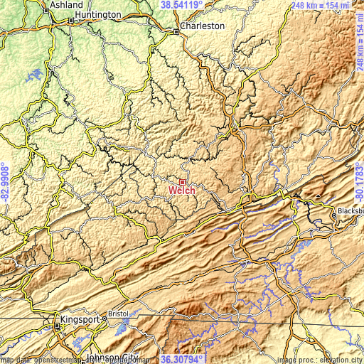
Below is the Elevation map of Welch, which displays elevation range with different colors. Scale of the first map is from 376 to 712 m (1234 to 2336 ft) with average elevation of 551.8 meters (=1810 ft) [note 1]
These maps also provides idea of topography and contour of this city, they are displayed at different zoom levels. More info about maps, scale and edge coordinates you can find below images.

| \ | Map #1 | Topo.Map |
| Scale [m] | 376..712 m | × |
| Scale [ft] | 1234..2336 ft | × |
| Average | 551.8 m = 1810 ft | × |
| Width | 7.76 km = 4.8 mi | 248.3 km = 154.3 mi |
| Height | 7.76 km = 4.8 mi | 248.3 km = 154.3 mi |
| ↑Max Latitude | 37.467777° | 38.54119° |
| Latitude at center | 37.43289° | 37.43289° |
| ↓Min Latitude | 37.397986° | 36.30794° |
| ← Min Longitude | -81.628495° | -82.9908° |
| Longitude center | -81.58455° | -81.58455° |
| →Max Longitude | -81.540605° | -80.1783° |
Nearby cities:
Cities around Welch sort by population:
• Bluefield elevation 782 m
36.8 km,  119°
119°
• Bluefield 723 m
34.2 km,  125°
125°
• Tazewell 764 m
35.8 km,  170°
170°
• Bluewell 793 m
31.7 km,  114°
114°
• Mallory 244 m
39.9 km,  326°
326°
• Mullens 436 m
24.6 km,  47°
47°
• Springville 814 m
30.8 km,  148°
148°
• Oceana 380 m
29 km,  353°
353°
• Brush Fork 732 m
33.6 km, 120°
• Gilbert Creek 346 m
31.7 km,  300°
300°
• Cedar Bluff 601 m
41.4 km,  201°
201°
• Pineville 396 m
17.2 km,  14°
14°
Multilingual:
 En español:
Welch elevación 405 m.
 En France:
Welch élévation 405 m.


Sources and notes:
- [note 1] Map square and city borders are not equal. Map elevation data is calculated only from area inside that square.
- [src 1] Elevation data from geonames database provided with same terms of usage.
- [src 2] The elevation map of Welch is generated using elevation data from NASA's 3 arcsec (90m) resolution SRTM data.
- [src 3] Base (background) map © OpenStreetMap contributors tiles are generated by Geofabrik and OpenTopoMap.
Copyright & License:
This Welch Elevation Map is licensed under CC BY-SA. You may reuse any part from this page, if you give a proper credit by linking to this URL:
 More info on terms of use page.