Tazewell elevation
Tazewell (Virginia, Tazewell County), United States elevation is 764 meters and Tazewell elevation in feet is 2507 ft above sea level [src 1]. Tazewell is a seat of a second-order administrative division (feature code) with elevation that is 485 meters (1591 ft) bigger than average city elevation in United States.
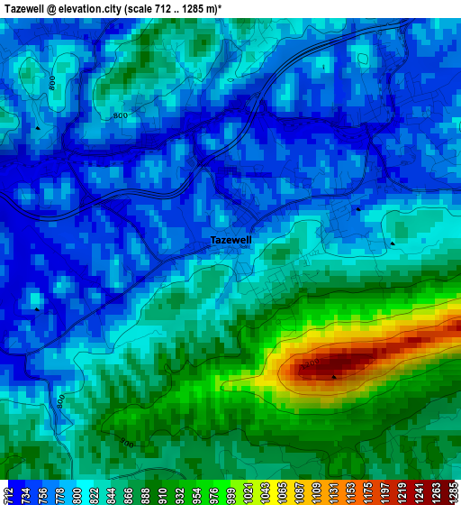
Below is the Elevation map of Tazewell, which displays elevation range with different colors. Scale of the first map is from 712 to 1285 m (2336 to 4216 ft) with average elevation of 829.5 meters (=2721 ft) [note 1]
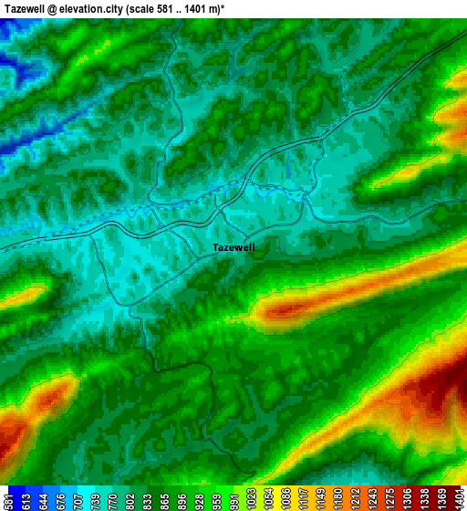
These maps also provides idea of topography and contour of this city, they are displayed at different zoom levels. More info about maps, scale and edge coordinates you can find below images.
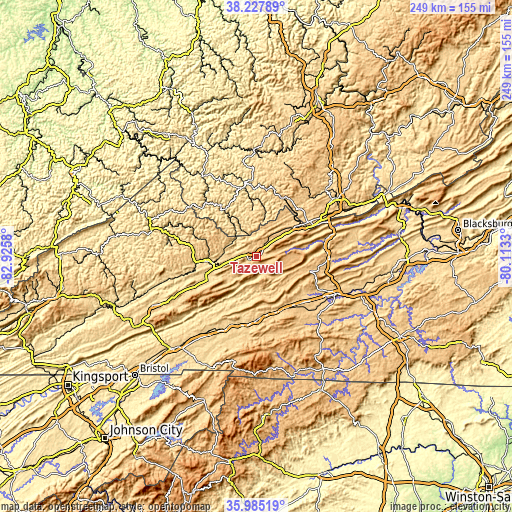
| \ | Map #1 | Map #2 | Topo.Map |
| Scale [m] | 712..1285 m | 581..1401 m | × |
| Scale [ft] | 2336..4216 ft | 1906..4596 ft | × |
| Average | 829.5 m = 2721 ft | 867.1 m = 2845 ft | × |
| Width | 7.79 km = 4.8 mi | 15.59 km = 9.7 mi | 249.4 km = 155 mi |
| Height | 7.79 km = 4.8 mi | 15.59 km = 9.7 mi | 249.4 km = 155 mi |
| ↑Max Latitude | 37.149875° | 37.184894° | 38.22789° |
| Latitude at center | 37.11484° | 37.11484° | 37.11484° |
| ↓Min Latitude | 37.079789° | 37.044721° | 35.98519° |
| ← Min Longitude | -81.563495° | -81.607441° | -82.9258° |
| Longitude center | -81.51955° | -81.51955° | -81.51955° |
| →Max Longitude | -81.475605° | -81.431659° | -80.1133° |
Nearby cities:
Cities around Tazewell sort by population:
• Bluefield elevation 782 m
31.5 km,  56°
56°
• Marion 661 m
31.1 km,  179°
179°
• Richlands 588 m
24.4 km,  264°
264°
• Bluefield 723 m
26.8 km, 55°
• Raven 581 m
29.9 km, 264°
• Bluewell 793 m
31.8 km,  46°
46°
• Claypool Hill 710 m
21.4 km,  254°
254°
• Rural Retreat 764 m
32.7 km,  138°
138°
• Springville 814 m
13.8 km, 48°
• Brush Fork 732 m
29.8 km, 51°
• Atkins 700 m
28.8 km,  162°
162°
• Cedar Bluff 601 m
21.4 km, 261°
Multilingual:
 En español:
Tazewell elevación 764 m.
 En France:
Tazewell élévation 764 m.
 Auf Deutsch:
Tazewell höhe über dem Meeresspiegel ist 764 m.

Sources and notes:
- [note 1] Map square and city borders are not equal. Map elevation data is calculated only from area inside that square.
- [src 1] Elevation data from geonames database provided with same terms of usage.
- [src 2] The elevation map of Tazewell is generated using elevation data from NASA's 3 arcsec (90m) resolution SRTM data.
- [src 3] Base (background) map © OpenStreetMap contributors tiles are generated by Geofabrik and OpenTopoMap.
Copyright & License:
This Tazewell Elevation Map is licensed under CC BY-SA. You may reuse any part from this page, if you give a proper credit by linking to this URL:
 More info on terms of use page.