Bluefield elevation
Bluefield (Virginia, Tazewell County), United States elevation is 723 meters and Bluefield elevation in feet is 2372 ft above sea level [src 1]. Bluefield is a populated place (feature code) with elevation that is 444 meters (1457 ft) bigger than average city elevation in United States.
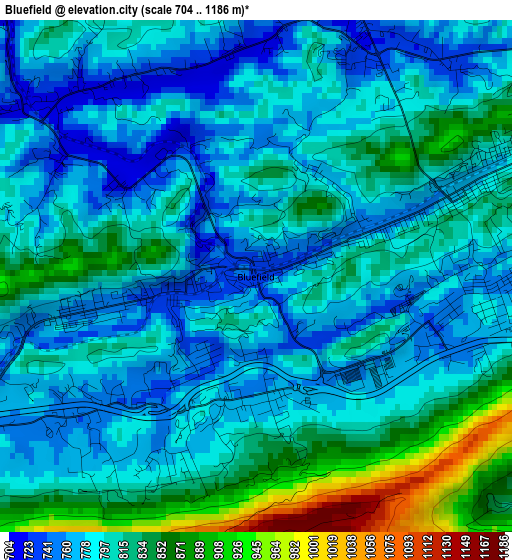
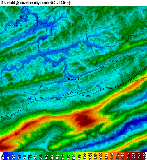
Below is the Elevation map of Bluefield, which displays elevation range with different colors. Scale of the first map is from 704 to 1186 m (2310 to 3891 ft) with average elevation of 804.1 meters (=2638 ft) [note 1]
These maps also provides idea of topography and contour of this city, they are displayed at different zoom levels. More info about maps, scale and edge coordinates you can find below images.
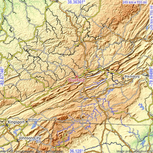
| \ | Map #1 | Map #2 | Topo.Map |
| Scale [m] | 704..1186 m | 660..1250 m | × |
| Scale [ft] | 2310..3891 ft | 2165..4101 ft | × |
| Average | 804.1 m = 2638 ft | 830.5 m = 2725 ft | × |
| Width | 7.78 km = 4.8 mi | 15.56 km = 9.7 mi | 248.9 km = 154.7 mi |
| Height | 7.78 km = 4.8 mi | 15.56 km = 9.7 mi | 248.9 km = 154.7 mi |
| ↑Max Latitude | 37.287591° | 37.322546° | 38.36361° |
| Latitude at center | 37.25262° | 37.25262° | 37.25262° |
| ↓Min Latitude | 37.217633° | 37.182629° | 36.125° |
| ← Min Longitude | -81.315155° | -81.359101° | -82.67746° |
| Longitude center | -81.27121° | -81.27121° | -81.27121° |
| →Max Longitude | -81.227265° | -81.183319° | -79.86496° |
Nearby cities:
Cities around Bluefield sort by population:
• Bluefield elevation 782 m
4.7 km,  66°
66°
• Wytheville 697 m
37.6 km,  153°
153°
• Princeton 744 m
19.5 km,  49°
49°
• Tazewell 764 m
26.8 km,  235°
235°
• Bluewell 793 m
6.7 km,  8°
8°
• Welch 405 m
34.2 km,  305°
305°
• Narrows 475 m
41.6 km,  77°
77°
• Rural Retreat 764 m
39.9 km,  180°
180°
• Mullens 436 m
38 km,  345°
345°
• Springville 814 m
13.2 km, 241°
• Brush Fork 732 m
3.4 km,  23°
23°
• Bland 743 m
21.7 km,  140°
140°
Multilingual:
 En español:
Bluefield elevación 723 m.
 En France:
Bluefield élévation 723 m.
 Auf Deutsch:
Bluefield höhe über dem Meeresspiegel ist 723 m.

Sources and notes:
- [note 1] Map square and city borders are not equal. Map elevation data is calculated only from area inside that square.
- [src 1] Elevation data from geonames database provided with same terms of usage.
- [src 2] The elevation map of Bluefield is generated using elevation data from NASA's 3 arcsec (90m) resolution SRTM data.
- [src 3] Base (background) map © OpenStreetMap contributors tiles are generated by Geofabrik and OpenTopoMap.
Copyright & License:
This Bluefield Elevation Map is licensed under CC BY-SA. You may reuse any part from this page, if you give a proper credit by linking to this URL:
 More info on terms of use page.