Wytheville elevation
Wytheville (Virginia, Wythe County), United States elevation is 697 meters and Wytheville elevation in feet is 2287 ft above sea level [src 1]. Wytheville is a seat of a second-order administrative division (feature code) with elevation that is 418 meters (1371 ft) bigger than average city elevation in United States.
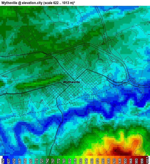
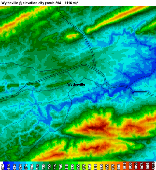
Below is the Elevation map of Wytheville, which displays elevation range with different colors. Scale of the first map is from 622 to 1013 m (2041 to 3323 ft) with average elevation of 717.7 meters (=2355 ft) [note 1]
These maps also provides idea of topography and contour of this city, they are displayed at different zoom levels. More info about maps, scale and edge coordinates you can find below images.
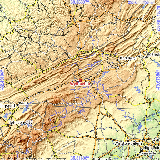
| \ | Map #1 | Map #2 | Topo.Map |
| Scale [m] | 622..1013 m | 594..1116 m | × |
| Scale [ft] | 2041..3323 ft | 1949..3661 ft | × |
| Average | 717.7 m = 2355 ft | 756.9 m = 2483 ft | × |
| Width | 7.81 km = 4.9 mi | 15.62 km = 9.7 mi | 249.9 km = 155.3 mi |
| Height | 7.81 km = 4.9 mi | 15.62 km = 9.7 mi | 249.9 km = 155.3 mi |
| ↑Max Latitude | 36.983562° | 37.018658° | 38.06397° |
| Latitude at center | 36.94845° | 36.94845° | 36.94845° |
| ↓Min Latitude | 36.913322° | 36.878177° | 35.81635° |
| ← Min Longitude | -81.128755° | -81.172701° | -82.49106° |
| Longitude center | -81.08481° | -81.08481° | -81.08481° |
| →Max Longitude | -81.040865° | -80.996919° | -79.67856° |
Nearby cities:
Cities around Wytheville sort by population:
• Bluefield elevation 782 m
37.8 km,  341°
341°
• Pulaski 582 m
29.3 km,  67°
67°
• Galax 723 m
35 km,  155°
155°
• Bluefield 723 m
37.6 km,  333°
333°
• Dublin 632 m
39.5 km,  63°
63°
• Hillsville 764 m
37.4 km,  123°
123°
• Woodlawn 768 m
34.3 km,  137°
137°
• Rural Retreat 764 m
18 km,  250°
250°
• Springville 814 m
39.5 km,  314°
314°
• Atkins 700 m
31.4 km, 253°
• Independence 825 m
36.8 km,  189°
189°
• Bland 743 m
17.3 km,  350°
350°
Multilingual:
 En español:
Wytheville elevación 697 m.
 En France:
Wytheville élévation 697 m.
 Auf Deutsch:
Wytheville höhe über dem Meeresspiegel ist 697 m.

Sources and notes:
- [note 1] Map square and city borders are not equal. Map elevation data is calculated only from area inside that square.
- [src 1] Elevation data from geonames database provided with same terms of usage.
- [src 2] The elevation map of Wytheville is generated using elevation data from NASA's 3 arcsec (90m) resolution SRTM data.
- [src 3] Base (background) map © OpenStreetMap contributors tiles are generated by Geofabrik and OpenTopoMap.
Copyright & License:
This Wytheville Elevation Map is licensed under CC BY-SA. You may reuse any part from this page, if you give a proper credit by linking to this URL:
 More info on terms of use page.