Woodlawn elevation
Woodlawn (Virginia, Carroll County), United States elevation is 768 meters and Woodlawn elevation in feet is 2520 ft above sea level [src 1]. Woodlawn is a populated place (feature code) with elevation that is 489 meters (1604 ft) bigger than average city elevation in United States.
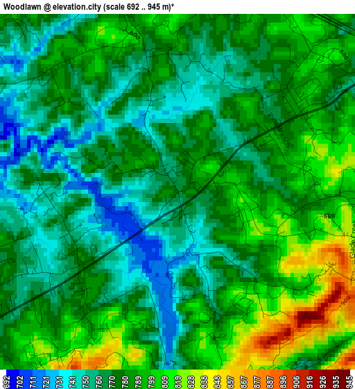
Below is the Elevation map of Woodlawn, which displays elevation range with different colors. Scale of the first map is from 692 to 945 m (2270 to 3100 ft) with average elevation of 778.7 meters (=2555 ft) [note 1]
These maps also provides idea of topography and contour of this city, they are displayed at different zoom levels. More info about maps, scale and edge coordinates you can find below images.
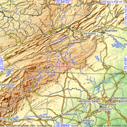
| \ | Map #1 | Topo.Map |
| Scale [m] | 692..945 m | × |
| Scale [ft] | 2270..3100 ft | × |
| Average | 778.7 m = 2555 ft | × |
| Width | 7.83 km = 4.9 mi | 250.7 km = 155.8 mi |
| Height | 7.83 km = 4.9 mi | 250.6 km = 155.7 mi |
| ↑Max Latitude | 36.757566° | 37.84122° |
| Latitude at center | 36.72235° | 36.72235° |
| ↓Min Latitude | 36.687118° | 35.58694° |
| ← Min Longitude | -80.866795° | -82.2291° |
| Longitude center | -80.82285° | -80.82285° |
| →Max Longitude | -80.778905° | -79.4166° |
Nearby cities:
Cities around Woodlawn sort by population:
• Mount Airy elevation 336 m
31.4 km,  142°
142°
• Pulaski 582 m
36.4 km,  6°
6°
• Wytheville 697 m
34.3 km,  317°
317°
• Galax 723 m
11.3 km,  232°
232°
• Hillsville 764 m
9 km,  60°
60°
• Sparta 890 m
35.9 km, 227°
• Dobson 382 m
37.4 km,  166°
166°
• Flat Rock 349 m
32.5 km, 135°
• Toast 323 m
30.3 km, 144°
• Cana 435 m
20 km, 137°
• White Plains 343 m
35.1 km,  151°
151°
• Independence 825 m
31.5 km,  249°
249°
Multilingual:
 En español:
Woodlawn elevación 768 m.
 En France:
Woodlawn élévation 768 m.
 Auf Deutsch:
Woodlawn höhe über dem Meeresspiegel ist 768 m.

Sources and notes:
- [note 1] Map square and city borders are not equal. Map elevation data is calculated only from area inside that square.
- [src 1] Elevation data from geonames database provided with same terms of usage.
- [src 2] The elevation map of Woodlawn is generated using elevation data from NASA's 3 arcsec (90m) resolution SRTM data.
- [src 3] Base (background) map © OpenStreetMap contributors tiles are generated by Geofabrik and OpenTopoMap.
Copyright & License:
This Woodlawn Elevation Map is licensed under CC BY-SA. You may reuse any part from this page, if you give a proper credit by linking to this URL:
 More info on terms of use page.