Sparta elevation
Sparta (North Carolina, Alleghany County), United States elevation is 890 meters and Sparta elevation in feet is 2920 ft above sea level [src 1]. Sparta is a seat of a second-order administrative division (feature code) with elevation that is 611 meters (2005 ft) bigger than average city elevation in United States.
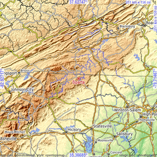
Below is the Elevation map of Sparta, which displays elevation range with different colors. Scale of the first map is from 770 to 1131 m (2526 to 3711 ft) with average elevation of 909.6 meters (=2984 ft) [note 1]
These maps also provides idea of topography and contour of this city, they are displayed at different zoom levels. More info about maps, scale and edge coordinates you can find below images.

| \ | Map #1 | Topo.Map |
| Scale [m] | 770..1131 m | × |
| Scale [ft] | 2526..3711 ft | × |
| Average | 909.6 m = 2984 ft | × |
| Width | 7.86 km = 4.9 mi | 251.4 km = 156.2 mi |
| Height | 7.86 km = 4.9 mi | 251.4 km = 156.2 mi |
| ↑Max Latitude | 36.540725° | 37.62747° |
| Latitude at center | 36.50541° | 36.50541° |
| ↓Min Latitude | 36.470079° | 35.36685° |
| ← Min Longitude | -81.164865° | -82.52717° |
| Longitude center | -81.12092° | -81.12092° |
| →Max Longitude | -81.076975° | -79.71467° |
Nearby cities:
Cities around Sparta sort by population:
• Galax elevation 723 m
24.7 km,  45°
45°
• Woodlawn 768 m
35.9 km, 47°
• Mulberry 401 m
30 km,  190°
190°
• Fairplains 391 m
34.2 km,  184°
184°
• Millers Creek 430 m
36.7 km,  196°
196°
• Cricket 384 m
37.7 km, 189°
• Hays 412 m
28.4 km, 179°
• Thurmond 425 m
23.1 km,  131°
131°
• Jefferson 888 m
32.9 km,  253°
253°
• Dobson 382 m
37.7 km,  108°
108°
• West Jefferson 906 m
35.1 km, 251°
• Independence 825 m
13.3 km,  347°
347°
Multilingual:
 En español:
Sparta elevación 890 m.
 En France:
Sparta élévation 890 m.


Sources and notes:
- [note 1] Map square and city borders are not equal. Map elevation data is calculated only from area inside that square.
- [src 1] Elevation data from geonames database provided with same terms of usage.
- [src 2] The elevation map of Sparta is generated using elevation data from NASA's 3 arcsec (90m) resolution SRTM data.
- [src 3] Base (background) map © OpenStreetMap contributors tiles are generated by Geofabrik and OpenTopoMap.
Copyright & License:
This Sparta Elevation Map is licensed under CC BY-SA. You may reuse any part from this page, if you give a proper credit by linking to this URL:
 More info on terms of use page.