Cana elevation
Cana (Virginia, Carroll County), United States elevation is 435 meters and Cana elevation in feet is 1427 ft above sea level [src 1]. Cana is a populated place (feature code) with elevation that is 156 meters (512 ft) bigger than average city elevation in United States.
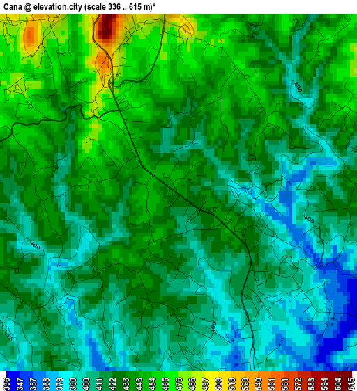
Below is the Elevation map of Cana, which displays elevation range with different colors. Scale of the first map is from 336 to 615 m (1102 to 2018 ft) with average elevation of 425 meters (=1394 ft) [note 1]
These maps also provides idea of topography and contour of this city, they are displayed at different zoom levels. More info about maps, scale and edge coordinates you can find below images.
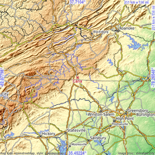
| \ | Map #1 | Topo.Map |
| Scale [m] | 336..615 m | × |
| Scale [ft] | 1102..2018 ft | × |
| Average | 425 m = 1394 ft | × |
| Width | 7.85 km = 4.9 mi | 251.1 km = 156 mi |
| Height | 7.85 km = 4.9 mi | 251.1 km = 156 mi |
| ↑Max Latitude | 36.624857° | 37.7104° |
| Latitude at center | 36.58958° | 36.58958° |
| ↓Min Latitude | 36.554287° | 35.45224° |
| ← Min Longitude | -80.715675° | -82.07798° |
| Longitude center | -80.67173° | -80.67173° |
| →Max Longitude | -80.627785° | -79.26548° |
Nearby cities:
Cities around Cana sort by population:
• Mount Airy elevation 336 m
11.6 km,  150°
150°
• Galax 723 m
23.9 km,  289°
289°
• Hillsville 764 m
20 km,  343°
343°
• Woodlawn 768 m
20 km,  317°
317°
• Thurmond 425 m
33.8 km,  222°
222°
• Dobson 382 m
22 km,  191°
191°
• Flat Rock 349 m
12.5 km,  133°
133°
• Pilot Mountain 353 m
28.9 km,  141°
141°
• Toast 323 m
10.7 km,  157°
157°
• Stuart 408 m
36.7 km,  81°
81°
• Boonville 326 m
39.8 km,  184°
184°
• White Plains 343 m
16.4 km,  167°
167°
Multilingual:
 En español:
Cana elevación 435 m.
 En France:
Cana élévation 435 m.


Sources and notes:
- [note 1] Map square and city borders are not equal. Map elevation data is calculated only from area inside that square.
- [src 1] Elevation data from geonames database provided with same terms of usage.
- [src 2] The elevation map of Cana is generated using elevation data from NASA's 3 arcsec (90m) resolution SRTM data.
- [src 3] Base (background) map © OpenStreetMap contributors tiles are generated by Geofabrik and OpenTopoMap.
Copyright & License:
This Cana Elevation Map is licensed under CC BY-SA. You may reuse any part from this page, if you give a proper credit by linking to this URL:
 More info on terms of use page.