Pilot Mountain elevation
Pilot Mountain (North Carolina, Surry County), United States elevation is 353 meters and Pilot Mountain elevation in feet is 1158 ft above sea level [src 1]. Pilot Mountain is a populated place (feature code) with elevation that is 74 meters (243 ft) bigger than average city elevation in United States.
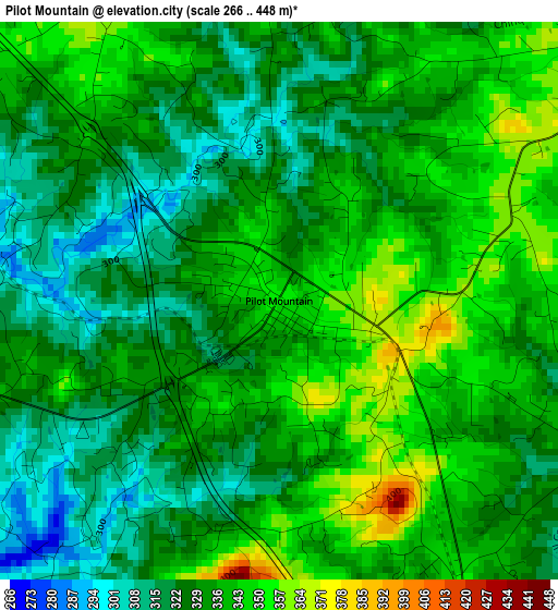
Below is the Elevation map of Pilot Mountain, which displays elevation range with different colors. Scale of the first map is from 266 to 448 m (873 to 1470 ft) with average elevation of 332.5 meters (=1091 ft) [note 1]
These maps also provides idea of topography and contour of this city, they are displayed at different zoom levels. More info about maps, scale and edge coordinates you can find below images.
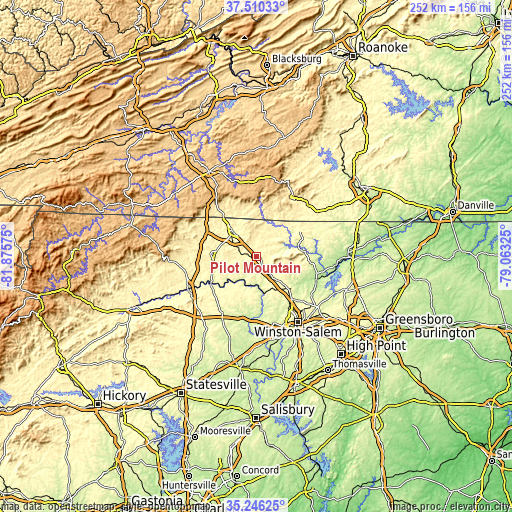
| \ | Map #1 | Topo.Map |
| Scale [m] | 266..448 m | × |
| Scale [ft] | 873..1470 ft | × |
| Average | 332.5 m = 1091 ft | × |
| Width | 7.87 km = 4.9 mi | 251.7 km = 156.4 mi |
| Height | 7.87 km = 4.9 mi | 251.7 km = 156.4 mi |
| ↑Max Latitude | 36.421899° | 37.51033° |
| Latitude at center | 36.38653° | 36.38653° |
| ↓Min Latitude | 36.351145° | 35.24625° |
| ← Min Longitude | -80.513445° | -81.87575° |
| Longitude center | -80.4695° | -80.4695° |
| →Max Longitude | -80.425555° | -79.06325° |
Nearby cities:
Cities around Pilot Mountain sort by population:
• Mount Airy elevation 336 m
17.6 km,  315°
315°
• King 338 m
15.4 km,  139°
139°
• Rural Hall 309 m
22.6 km, 135°
• Tobaccoville 311 m
18.7 km,  151°
151°
• Dobson 382 m
22.7 km,  272°
272°
• Flat Rock 349 m
16.6 km,  327°
327°
• Toast 323 m
18.9 km,  312°
312°
• Walnut Cove 197 m
31.1 km,  109°
109°
• Cana 435 m
28.9 km, 321°
• Boonville 326 m
27.4 km,  231°
231°
• White Plains 343 m
16.1 km,  294°
294°
• Danbury 248 m
23.7 km,  83°
83°
Multilingual:
 En español:
Pilot Mountain elevación 353 m.
 En France:
Pilot Mountain élévation 353 m.
 Auf Deutsch:
Pilot Mountain höhe über dem Meeresspiegel ist 353 m.

Sources and notes:
- [note 1] Map square and city borders are not equal. Map elevation data is calculated only from area inside that square.
- [src 1] Elevation data from geonames database provided with same terms of usage.
- [src 2] The elevation map of Pilot Mountain is generated using elevation data from NASA's 3 arcsec (90m) resolution SRTM data.
- [src 3] Base (background) map © OpenStreetMap contributors tiles are generated by Geofabrik and OpenTopoMap.
Copyright & License:
This Pilot Mountain Elevation Map is licensed under CC BY-SA. You may reuse any part from this page, if you give a proper credit by linking to this URL:
 More info on terms of use page.