Walnut Cove elevation
Walnut Cove (North Carolina, Stokes County), United States elevation is 197 meters and Walnut Cove elevation in feet is 646 ft above sea level [src 1]. Walnut Cove is a populated place (feature code) with elevation that is 82 meters (269 ft) smaller than average city elevation in United States.
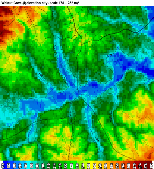
Below is the Elevation map of Walnut Cove, which displays elevation range with different colors. Scale of the first map is from 178 to 282 m (584 to 925 ft) with average elevation of 216.3 meters (=710 ft) [note 1]
These maps also provides idea of topography and contour of this city, they are displayed at different zoom levels. More info about maps, scale and edge coordinates you can find below images.
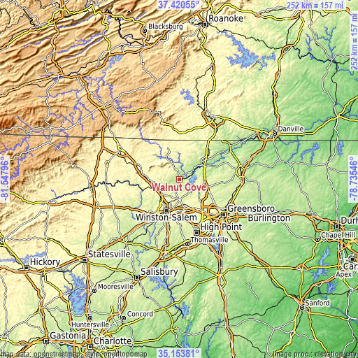
| \ | Map #1 | Topo.Map |
| Scale [m] | 178..282 m | × |
| Scale [ft] | 584..925 ft | × |
| Average | 216.3 m = 710 ft | × |
| Width | 7.88 km = 4.9 mi | 252 km = 156.6 mi |
| Height | 7.88 km = 4.9 mi | 252 km = 156.6 mi |
| ↑Max Latitude | 36.330821° | 37.42055° |
| Latitude at center | 36.29541° | 36.29541° |
| ↓Min Latitude | 36.259983° | 35.15381° |
| ← Min Longitude | -80.185655° | -81.54796° |
| Longitude center | -80.14171° | -80.14171° |
| →Max Longitude | -80.097765° | -78.73546° |
Nearby cities:
Cities around Walnut Cove sort by population:
• Winston-Salem elevation 283 m
23.6 km,  202°
202°
• Kernersville 307 m
20.5 km,  162°
162°
• Summerfield 276 m
23.3 km,  114°
114°
• King 338 m
19.6 km,  265°
265°
• Oak Ridge 284 m
19.3 km,  134°
134°
• Stokesdale 289 m
15.9 km, 114°
• Walkertown 302 m
13.4 km,  184°
184°
• Rural Hall 309 m
14.9 km,  245°
245°
• Tobaccoville 311 m
21.6 km, 252°
• Mayodan 189 m
20.3 km,  50°
50°
• Madison 188 m
19.1 km,  58°
58°
• Danbury 248 m
13.9 km,  335°
335°
Multilingual:
 En español:
Walnut Cove elevación 197 m.
 En France:
Walnut Cove élévation 197 m.
 Auf Deutsch:
Walnut Cove höhe über dem Meeresspiegel ist 197 m.

Sources and notes:
- [note 1] Map square and city borders are not equal. Map elevation data is calculated only from area inside that square.
- [src 1] Elevation data from geonames database provided with same terms of usage.
- [src 2] The elevation map of Walnut Cove is generated using elevation data from NASA's 3 arcsec (90m) resolution SRTM data.
- [src 3] Base (background) map © OpenStreetMap contributors tiles are generated by Geofabrik and OpenTopoMap.
Copyright & License:
This Walnut Cove Elevation Map is licensed under CC BY-SA. You may reuse any part from this page, if you give a proper credit by linking to this URL:
 More info on terms of use page.