Marion elevation
Marion (Virginia, Smyth County), United States elevation is 661 meters and Marion elevation in feet is 2169 ft above sea level [src 1]. Marion is a seat of a second-order administrative division (feature code) with elevation that is 382 meters (1253 ft) bigger than average city elevation in United States.
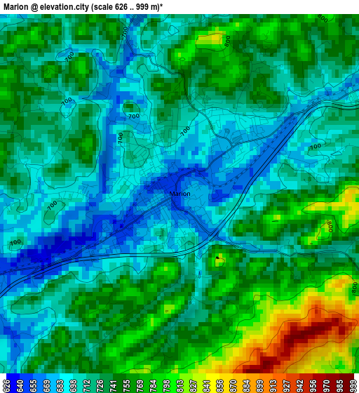
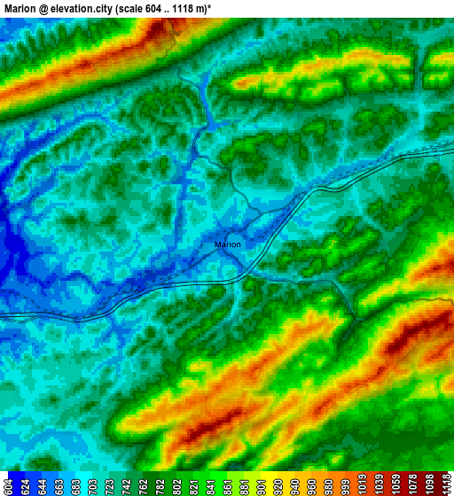
Below is the Elevation map of Marion, which displays elevation range with different colors. Scale of the first map is from 626 to 999 m (2054 to 3278 ft) with average elevation of 732.2 meters (=2402 ft) [note 1]
These maps also provides idea of topography and contour of this city, they are displayed at different zoom levels. More info about maps, scale and edge coordinates you can find below images.
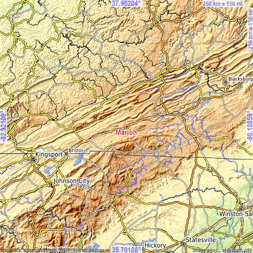
| \ | Map #1 | Map #2 | Topo.Map |
| Scale [m] | 626..999 m | 604..1118 m | × |
| Scale [ft] | 2054..3278 ft | 1982..3668 ft | × |
| Average | 732.2 m = 2402 ft | 776.5 m = 2548 ft | × |
| Width | 7.82 km = 4.9 mi | 15.64 km = 9.7 mi | 250.3 km = 155.5 mi |
| Height | 7.82 km = 4.9 mi | 15.64 km = 9.7 mi | 250.3 km = 155.5 mi |
| ↑Max Latitude | 36.870004° | 36.905152° | 37.95204° |
| Latitude at center | 36.83484° | 36.83484° | 36.83484° |
| ↓Min Latitude | 36.79966° | 36.764463° | 35.70108° |
| ← Min Longitude | -81.558785° | -81.602731° | -82.92109° |
| Longitude center | -81.51484° | -81.51484° | -81.51484° |
| →Max Longitude | -81.470895° | -81.426949° | -80.10859° |
Nearby cities:
Cities around Marion sort by population:
• Richlands elevation 588 m
37.9 km,  319°
319°
• Tazewell 764 m
31.1 km,  359°
359°
• Saltville 529 m
22.6 km,  283°
283°
• Claypool Hill 710 m
32.9 km, 320°
• Chilhowie 592 m
15.4 km,  254°
254°
• Adwolf 711 m
7.8 km,  229°
229°
• Rural Retreat 764 m
22.2 km,  72°
72°
• Glade Spring 630 m
23.3 km,  258°
258°
• Emory 652 m
29.4 km, 256°
• Atkins 700 m
8.9 km, 66°
• Cedar Bluff 601 m
35.5 km, 322°
• Independence 825 m
40 km,  126°
126°
Multilingual:
 En español:
Marion elevación 661 m.
 En France:
Marion élévation 661 m.


Sources and notes:
- [note 1] Map square and city borders are not equal. Map elevation data is calculated only from area inside that square.
- [src 1] Elevation data from geonames database provided with same terms of usage.
- [src 2] The elevation map of Marion is generated using elevation data from NASA's 3 arcsec (90m) resolution SRTM data.
- [src 3] Base (background) map © OpenStreetMap contributors tiles are generated by Geofabrik and OpenTopoMap.
Copyright & License:
This Marion Elevation Map is licensed under CC BY-SA. You may reuse any part from this page, if you give a proper credit by linking to this URL:
 More info on terms of use page.