Alderson elevation
Alderson (West Virginia, Greenbrier County), United States elevation is 471 meters and Alderson elevation in feet is 1545 ft above sea level [src 1]. Alderson is a populated place (feature code) with elevation that is 192 meters (630 ft) bigger than average city elevation in United States.
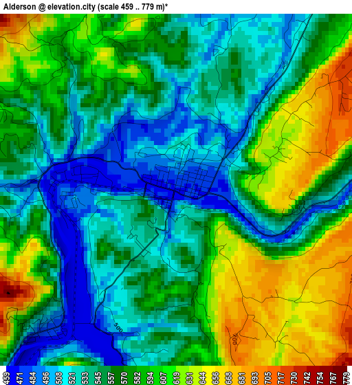
Below is the Elevation map of Alderson, which displays elevation range with different colors. Scale of the first map is from 459 to 779 m (1506 to 2556 ft) with average elevation of 567.8 meters (=1863 ft) [note 1]
These maps also provides idea of topography and contour of this city, they are displayed at different zoom levels. More info about maps, scale and edge coordinates you can find below images.
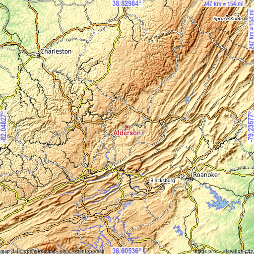
| \ | Map #1 | Topo.Map |
| Scale [m] | 459..779 m | × |
| Scale [ft] | 1506..2556 ft | × |
| Average | 567.8 m = 1863 ft | × |
| Width | 7.73 km = 4.8 mi | 247.3 km = 153.7 mi |
| Height | 7.73 km = 4.8 mi | 247.3 km = 153.7 mi |
| ↑Max Latitude | 37.7607° | 38.82984° |
| Latitude at center | 37.72595° | 37.72595° |
| ↓Min Latitude | 37.691183° | 36.60536° |
| ← Min Longitude | -80.685965° | -82.04827° |
| Longitude center | -80.64202° | -80.64202° |
| →Max Longitude | -80.598075° | -79.23577° |
Nearby cities:
Cities around Alderson sort by population:
• Lewisburg elevation 633 m
19.2 km,  63°
63°
• Shady Spring 823 m
40.2 km,  266°
266°
• Pearisburg 557 m
45.2 km,  190°
190°
• Hinton 446 m
22.5 km,  255°
255°
• White Sulphur Springs 566 m
31.3 km,  75°
75°
• Daniels 725 m
42.4 km, 272°
• Ronceverte 513 m
16 km, 80°
• Fairlea 659 m
17.4 km,  69°
69°
• Rainelle 729 m
29.1 km,  337°
337°
• Beaver 657 m
44.2 km, 273°
• Pembroke 503 m
45.2 km,  179°
179°
• Union 631 m
17.3 km,  149°
149°
Multilingual:
 En español:
Alderson elevación 471 m.
 En France:
Alderson élévation 471 m.
 Auf Deutsch:
Alderson höhe über dem Meeresspiegel ist 471 m.

Sources and notes:
- [note 1] Map square and city borders are not equal. Map elevation data is calculated only from area inside that square.
- [src 1] Elevation data from geonames database provided with same terms of usage.
- [src 2] The elevation map of Alderson is generated using elevation data from NASA's 3 arcsec (90m) resolution SRTM data.
- [src 3] Base (background) map © OpenStreetMap contributors tiles are generated by Geofabrik and OpenTopoMap.
Copyright & License:
This Alderson Elevation Map is licensed under CC BY-SA. You may reuse any part from this page, if you give a proper credit by linking to this URL:
 More info on terms of use page.