Shady Spring elevation
Shady Spring (West Virginia, Raleigh County), United States elevation is 823 meters and Shady Spring elevation in feet is 2700 ft above sea level [src 1]. Shady Spring is a populated place (feature code) with elevation that is 544 meters (1785 ft) bigger than average city elevation in United States.
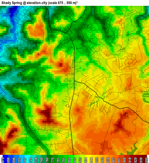
Below is the Elevation map of Shady Spring, which displays elevation range with different colors. Scale of the first map is from 675 to 950 m (2215 to 3117 ft) with average elevation of 824.3 meters (=2704 ft) [note 1]
These maps also provides idea of topography and contour of this city, they are displayed at different zoom levels. More info about maps, scale and edge coordinates you can find below images.
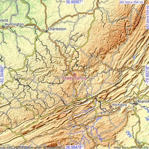
| \ | Map #1 | Topo.Map |
| Scale [m] | 675..950 m | × |
| Scale [ft] | 2215..3117 ft | × |
| Average | 824.3 m = 2704 ft | × |
| Width | 7.73 km = 4.8 mi | 247.4 km = 153.7 mi |
| Height | 7.73 km = 4.8 mi | 247.4 km = 153.7 mi |
| ↑Max Latitude | 37.74043° | 38.80987° |
| Latitude at center | 37.70567° | 37.70567° |
| ↓Min Latitude | 37.670894° | 36.58478° |
| ← Min Longitude | -81.142375° | -82.50468° |
| Longitude center | -81.09843° | -81.09843° |
| →Max Longitude | -81.054485° | -79.69218° |
Nearby cities:
Cities around Shady Spring sort by population:
• Beckley elevation 738 m
11.3 km,  315°
315°
• Crab Orchard 695 m
12.3 km,  288°
288°
• Hinton 446 m
18.7 km,  100°
100°
• Bradley 681 m
19.6 km,  334°
334°
• Daniels 725 m
4.8 km, 331°
• Coal City 797 m
10.3 km,  253°
253°
• MacArthur 742 m
11.6 km,  300°
300°
• Prosperity 750 m
17.1 km, 328°
• Mabscott 700 m
12.1 km,  306°
306°
• Stanaford 734 m
13.1 km,  338°
338°
• Sophia 706 m
13.4 km,  270°
270°
• Beaver 657 m
6.1 km, 319°
Multilingual:
 En español:
Shady Spring elevación 823 m.
 En France:
Shady Spring élévation 823 m.
 Auf Deutsch:
Shady Spring höhe über dem Meeresspiegel ist 823 m.

Sources and notes:
- [note 1] Map square and city borders are not equal. Map elevation data is calculated only from area inside that square.
- [src 1] Elevation data from geonames database provided with same terms of usage.
- [src 2] The elevation map of Shady Spring is generated using elevation data from NASA's 3 arcsec (90m) resolution SRTM data.
- [src 3] Base (background) map © OpenStreetMap contributors tiles are generated by Geofabrik and OpenTopoMap.
Copyright & License:
This Shady Spring Elevation Map is licensed under CC BY-SA. You may reuse any part from this page, if you give a proper credit by linking to this URL:
 More info on terms of use page.