Lewisburg elevation
Lewisburg (West Virginia, Greenbrier County), United States elevation is 633 meters and Lewisburg elevation in feet is 2077 ft above sea level [src 1]. Lewisburg is a seat of a second-order administrative division (feature code) with elevation that is 354 meters (1161 ft) bigger than average city elevation in United States.
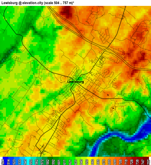
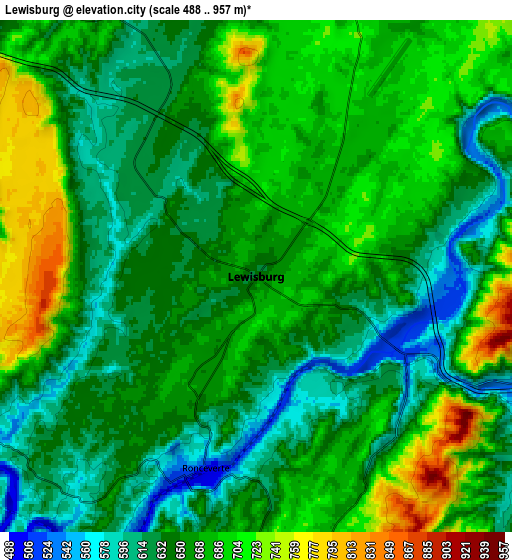
Below is the Elevation map of Lewisburg, which displays elevation range with different colors. Scale of the first map is from 504 to 757 m (1654 to 2484 ft) with average elevation of 649.2 meters (=2130 ft) [note 1]
These maps also provides idea of topography and contour of this city, they are displayed at different zoom levels. More info about maps, scale and edge coordinates you can find below images.
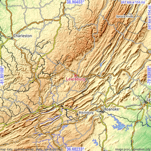
| \ | Map #1 | Map #2 | Topo.Map |
| Scale [m] | 504..757 m | 488..957 m | × |
| Scale [ft] | 1654..2484 ft | 1601..3140 ft | × |
| Average | 649.2 m = 2130 ft | 660.7 m = 2168 ft | × |
| Width | 7.72 km = 4.8 mi | 15.44 km = 9.6 mi | 247.1 km = 153.5 mi |
| Height | 7.72 km = 4.8 mi | 15.44 km = 9.6 mi | 247.1 km = 153.5 mi |
| ↑Max Latitude | 37.836505° | 37.871203° | 38.90453° |
| Latitude at center | 37.80179° | 37.80179° | 37.80179° |
| ↓Min Latitude | 37.767059° | 37.732312° | 36.68233° |
| ← Min Longitude | -80.489575° | -80.533521° | -81.85188° |
| Longitude center | -80.44563° | -80.44563° | -80.44563° |
| →Max Longitude | -80.401685° | -80.357739° | -79.03938° |
Nearby cities:
Cities around Lewisburg sort by population:
• Covington elevation 379 m
39.7 km,  91°
91°
• Clifton Forge 327 m
54.6 km, 88°
• Hinton 446 m
41.5 km,  249°
249°
• White Sulphur Springs 566 m
13 km, 92°
• Fairlawn 425 m
40.8 km, 93°
• Richwood 673 m
47.7 km,  350°
350°
• Ronceverte 513 m
6 km,  194°
194°
• Fairlea 659 m
2.6 km,  203°
203°
• Rainelle 729 m
33.8 km,  303°
303°
• Alderson 471 m
19.2 km,  243°
243°
• Union 631 m
24.9 km, 200°
• New Castle 410 m
44.6 km,  138°
138°
Multilingual:
 En español:
Lewisburg elevación 633 m.
 En France:
Lewisburg élévation 633 m.
 Auf Deutsch:
Lewisburg höhe über dem Meeresspiegel ist 633 m.

Sources and notes:
- [note 1] Map square and city borders are not equal. Map elevation data is calculated only from area inside that square.
- [src 1] Elevation data from geonames database provided with same terms of usage.
- [src 2] The elevation map of Lewisburg is generated using elevation data from NASA's 3 arcsec (90m) resolution SRTM data.
- [src 3] Base (background) map © OpenStreetMap contributors tiles are generated by Geofabrik and OpenTopoMap.
Copyright & License:
This Lewisburg Elevation Map is licensed under CC BY-SA. You may reuse any part from this page, if you give a proper credit by linking to this URL:
 More info on terms of use page.