Norton elevation
Norton (Virginia, City of Norton), United States elevation is 652 meters and Norton elevation in feet is 2139 ft above sea level [src 1]. Norton is a seat of a second-order administrative division (feature code) with elevation that is 373 meters (1224 ft) bigger than average city elevation in United States.
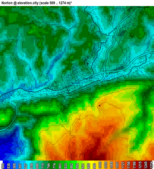
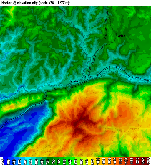
Below is the Elevation map of Norton, which displays elevation range with different colors. Scale of the first map is from 509 to 1274 m (1670 to 4180 ft) with average elevation of 790.8 meters (=2594 ft) [note 1]
These maps also provides idea of topography and contour of this city, they are displayed at different zoom levels. More info about maps, scale and edge coordinates you can find below images.
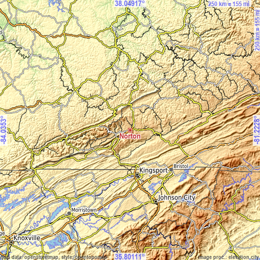
| \ | Map #1 | Map #2 | Topo.Map |
| Scale [m] | 509..1274 m | 478..1277 m | × |
| Scale [ft] | 1670..4180 ft | 1568..4190 ft | × |
| Average | 790.8 m = 2594 ft | 802.2 m = 2632 ft | × |
| Width | 7.81 km = 4.9 mi | 15.62 km = 9.7 mi | 250 km = 155.3 mi |
| Height | 7.81 km = 4.9 mi | 15.62 km = 9.7 mi | 250 km = 155.3 mi |
| ↑Max Latitude | 36.968549° | 37.003652° | 38.04917° |
| Latitude at center | 36.93343° | 36.93343° | 36.93343° |
| ↓Min Latitude | 36.898295° | 36.863144° | 35.80111° |
| ← Min Longitude | -82.672995° | -82.716941° | -84.0353° |
| Longitude center | -82.62905° | -82.62905° | -82.62905° |
| →Max Longitude | -82.585105° | -82.541159° | -81.2228° |
Nearby cities:
Cities around Norton sort by population:
• Big Stone Gap elevation 469 m
12 km,  241°
241°
• Wise 746 m
6.7 km,  45°
45°
• Cumberland 438 m
32.3 km,  278°
278°
• Jenkins 474 m
26.7 km,  359°
359°
• Castlewood 491 m
31.4 km,  98°
98°
• Whitesburg 358 m
27 km,  319°
319°
• Coeburn 609 m
14.7 km,  85°
85°
• Gate City 404 m
33.1 km,  172°
172°
• Appalachia 502 m
13.9 km,  257°
257°
• Clintwood 538 m
28.6 km,  32°
32°
• Weber City 400 m
35 km, 170°
• Dryden 441 m
32.8 km, 238°
Multilingual:
 En español:
Norton elevación 652 m.
 En France:
Norton élévation 652 m.


Sources and notes:
- [note 1] Map square and city borders are not equal. Map elevation data is calculated only from area inside that square.
- [src 1] Elevation data from geonames database provided with same terms of usage.
- [src 2] The elevation map of Norton is generated using elevation data from NASA's 3 arcsec (90m) resolution SRTM data.
- [src 3] Base (background) map © OpenStreetMap contributors tiles are generated by Geofabrik and OpenTopoMap.
Copyright & License:
This Norton Elevation Map is licensed under CC BY-SA. You may reuse any part from this page, if you give a proper credit by linking to this URL:
 More info on terms of use page.