Jenkins elevation
Jenkins (Kentucky, Letcher County), United States elevation is 474 meters and Jenkins elevation in feet is 1555 ft above sea level [src 1]. Jenkins is a populated place (feature code) with elevation that is 195 meters (640 ft) bigger than average city elevation in United States.
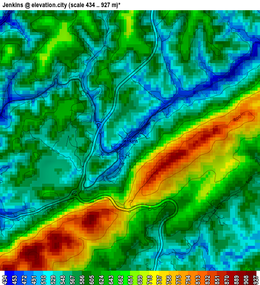
Below is the Elevation map of Jenkins, which displays elevation range with different colors. Scale of the first map is from 434 to 927 m (1424 to 3041 ft) with average elevation of 608.3 meters (=1996 ft) [note 1]
These maps also provides idea of topography and contour of this city, they are displayed at different zoom levels. More info about maps, scale and edge coordinates you can find below images.
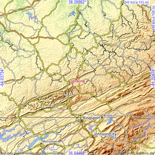
| \ | Map #1 | Topo.Map |
| Scale [m] | 434..927 m | × |
| Scale [ft] | 1424..3041 ft | × |
| Average | 608.3 m = 1996 ft | × |
| Width | 7.79 km = 4.8 mi | 249.2 km = 154.8 mi |
| Height | 7.79 km = 4.8 mi | 249.2 km = 154.8 mi |
| ↑Max Latitude | 37.208448° | 38.28562° |
| Latitude at center | 37.17344° | 37.17344° |
| ↓Min Latitude | 37.138416° | 36.04465° |
| ← Min Longitude | -82.674935° | -84.03724° |
| Longitude center | -82.63099° | -82.63099° |
| →Max Longitude | -82.587045° | -81.22474° |
Nearby cities:
Cities around Jenkins sort by population:
• Pikeville elevation 209 m
35.4 km,  16°
16°
• Big Stone Gap 469 m
34 km,  197°
197°
• Norton 652 m
26.7 km,  179°
179°
• Wise 746 m
22.5 km,  167°
167°
• Cumberland 438 m
38.4 km,  235°
235°
• Castlewood 491 m
44.3 km,  135°
135°
• Whitesburg 358 m
18.4 km,  250°
250°
• Coeburn 609 m
29.5 km,  149°
149°
• Appalachia 502 m
32.5 km, 204°
• Coal Run Village 207 m
38.3 km,  9°
9°
• Clintwood 538 m
15.7 km,  99°
99°
• Hindman 322 m
35.8 km,  300°
300°
Multilingual:
 En español:
Jenkins elevación 474 m.
 En France:
Jenkins élévation 474 m.


Sources and notes:
- [note 1] Map square and city borders are not equal. Map elevation data is calculated only from area inside that square.
- [src 1] Elevation data from geonames database provided with same terms of usage.
- [src 2] The elevation map of Jenkins is generated using elevation data from NASA's 3 arcsec (90m) resolution SRTM data.
- [src 3] Base (background) map © OpenStreetMap contributors tiles are generated by Geofabrik and OpenTopoMap.
Copyright & License:
This Jenkins Elevation Map is licensed under CC BY-SA. You may reuse any part from this page, if you give a proper credit by linking to this URL:
 More info on terms of use page.