Whitesburg elevation
Whitesburg (Kentucky, Letcher County), United States elevation is 358 meters and Whitesburg elevation in feet is 1175 ft above sea level [src 1]. Whitesburg is a seat of a second-order administrative division (feature code) with elevation that is 79 meters (259 ft) bigger than average city elevation in United States.
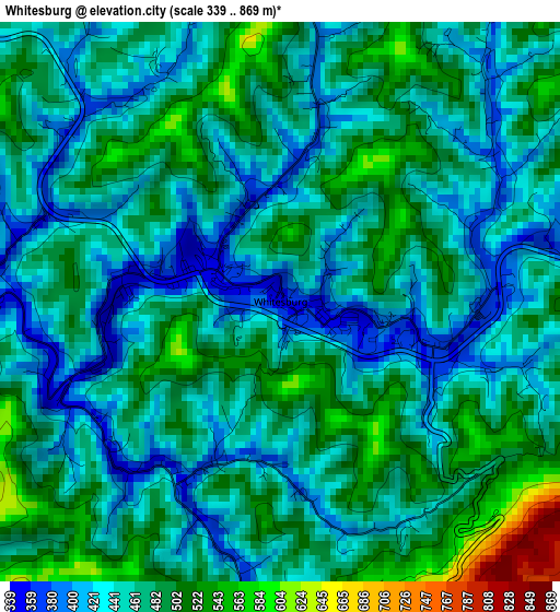
Below is the Elevation map of Whitesburg, which displays elevation range with different colors. Scale of the first map is from 339 to 869 m (1112 to 2851 ft) with average elevation of 466.5 meters (=1531 ft) [note 1]
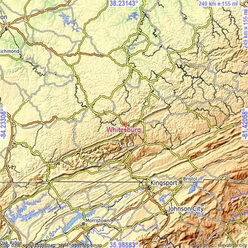
These maps also provides idea of topography and contour of this city, they are displayed at different zoom levels. More info about maps, scale and edge coordinates you can find below images.
| \ | Map #1 | Topo.Map |
| Scale [m] | 339..869 m | × |
| Scale [ft] | 1112..2851 ft | × |
| Average | 466.5 m = 1531 ft | × |
| Width | 7.79 km = 4.8 mi | 249.4 km = 155 mi |
| Height | 7.79 km = 4.8 mi | 249.4 km = 155 mi |
| ↑Max Latitude | 37.153463° | 38.23143° |
| Latitude at center | 37.11843° | 37.11843° |
| ↓Min Latitude | 37.08338° | 35.98883° |
| ← Min Longitude | -82.870775° | -84.23308° |
| Longitude center | -82.82683° | -82.82683° |
| →Max Longitude | -82.782885° | -81.42058° |
Nearby cities:
Cities around Whitesburg sort by population:
• Big Stone Gap elevation 469 m
27.3 km,  164°
164°
• Hazard 279 m
35.6 km,  294°
294°
• Norton 652 m
27 km,  139°
139°
• Wise 746 m
27.3 km,  125°
125°
• Cumberland 438 m
21.2 km,  222°
222°
• Jenkins 474 m
18.4 km,  70°
70°
• Coeburn 609 m
37.6 km,  121°
121°
• Pennington Gap 421 m
43.8 km,  203°
203°
• Appalachia 502 m
23.9 km,  170°
170°
• Clintwood 538 m
33.1 km,  83°
83°
• Dryden 441 m
39.2 km, 195°
• Hindman 322 m
27.7 km,  330°
330°
Multilingual:
 En español:
Whitesburg elevación 358 m.
 En France:
Whitesburg élévation 358 m.
 Auf Deutsch:
Whitesburg höhe über dem Meeresspiegel ist 358 m.

Sources and notes:
- [note 1] Map square and city borders are not equal. Map elevation data is calculated only from area inside that square.
- [src 1] Elevation data from geonames database provided with same terms of usage.
- [src 2] The elevation map of Whitesburg is generated using elevation data from NASA's 3 arcsec (90m) resolution SRTM data.
- [src 3] Base (background) map © OpenStreetMap contributors tiles are generated by Geofabrik and OpenTopoMap.
Copyright & License:
This Whitesburg Elevation Map is licensed under CC BY-SA. You may reuse any part from this page, if you give a proper credit by linking to this URL:
 More info on terms of use page.