Hazard elevation
Hazard (Kentucky, Perry County), United States elevation is 279 meters and Hazard elevation in feet is 915 ft above sea level [src 1]. Hazard is a seat of a second-order administrative division (feature code) with elevation that is 0 meters (0 ft) bigger than average city elevation in United States.
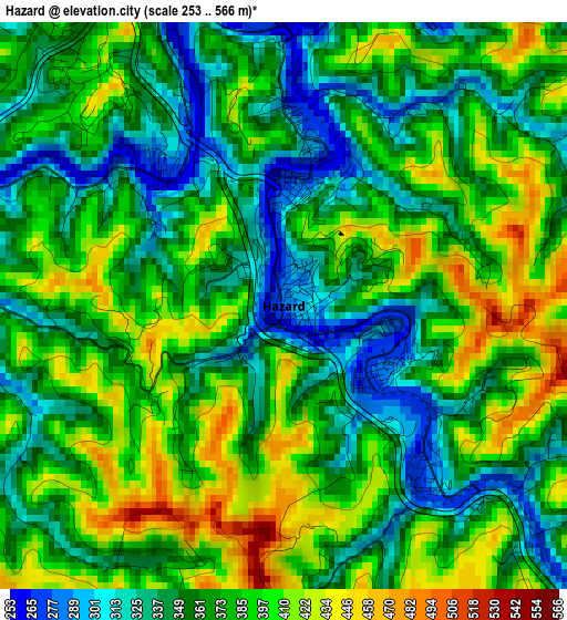
Below is the Elevation map of Hazard, which displays elevation range with different colors. Scale of the first map is from 253 to 566 m (830 to 1857 ft) with average elevation of 373.2 meters (=1224 ft) [note 1]
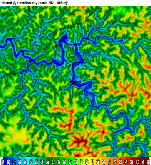
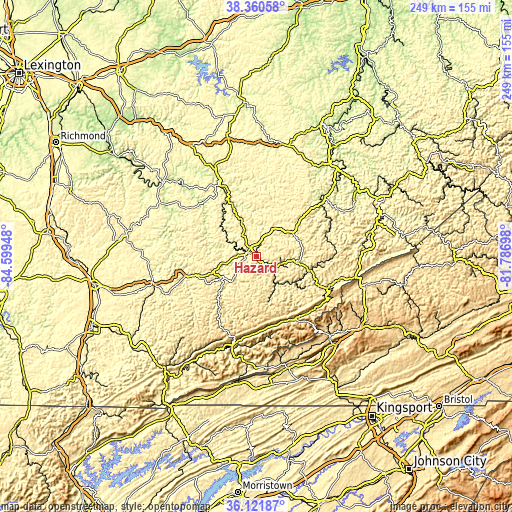
These maps also provides idea of topography and contour of this city, they are displayed at different zoom levels. More info about maps, scale and edge coordinates you can find below images.
| \ | Map #1 | Map #2 | Topo.Map |
| Scale [m] | 253..566 m | 252..606 m | × |
| Scale [ft] | 830..1857 ft | 827..1988 ft | × |
| Average | 373.2 m = 1224 ft | 392.4 m = 1287 ft | × |
| Width | 7.78 km = 4.8 mi | 15.56 km = 9.7 mi | 248.9 km = 154.7 mi |
| Height | 7.78 km = 4.8 mi | 15.56 km = 9.7 mi | 248.9 km = 154.7 mi |
| ↑Max Latitude | 37.284513° | 37.319469° | 38.36058° |
| Latitude at center | 37.24954° | 37.24954° | 37.24954° |
| ↓Min Latitude | 37.214551° | 37.179546° | 36.12187° |
| ← Min Longitude | -83.237175° | -83.281121° | -84.59948° |
| Longitude center | -83.19323° | -83.19323° | -83.19323° |
| →Max Longitude | -83.149285° | -83.105339° | -81.78698° |
Nearby cities:
Cities around Hazard sort by population:
• Big Stone Gap elevation 469 m
56.9 km,  135°
135°
• Jackson 240 m
37.7 km,  333°
333°
• Jenkins 474 m
50.5 km,  99°
99°
• Cumberland 438 m
35.2 km,  148°
148°
• Whitesburg 358 m
35.6 km,  114°
114°
• Pennington Gap 421 m
56.6 km,  164°
164°
• Appalachia 502 m
52.8 km, 136°
• Harlan 363 m
46.6 km,  194°
194°
• Manchester 278 m
51.5 km,  258°
258°
• Hindman 322 m
21.1 km,  62°
62°
• Hyden 278 m
18.7 km,  238°
238°
• Booneville 214 m
49.5 km,  300°
300°
Multilingual:
 En español:
Hazard elevación 279 m.
 En France:
Hazard élévation 279 m.


Sources and notes:
- [note 1] Map square and city borders are not equal. Map elevation data is calculated only from area inside that square.
- [src 1] Elevation data from geonames database provided with same terms of usage.
- [src 2] The elevation map of Hazard is generated using elevation data from NASA's 3 arcsec (90m) resolution SRTM data.
- [src 3] Base (background) map © OpenStreetMap contributors tiles are generated by Geofabrik and OpenTopoMap.
Copyright & License:
This Hazard Elevation Map is licensed under CC BY-SA. You may reuse any part from this page, if you give a proper credit by linking to this URL:
 More info on terms of use page.