Castlewood elevation
Castlewood (Virginia, Russell County), United States elevation is 491 meters and Castlewood elevation in feet is 1611 ft above sea level [src 1]. Castlewood is a populated place (feature code) with elevation that is 212 meters (696 ft) bigger than average city elevation in United States.
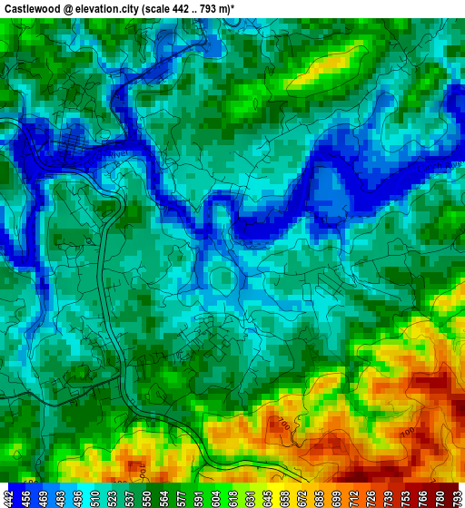
Below is the Elevation map of Castlewood, which displays elevation range with different colors. Scale of the first map is from 442 to 793 m (1450 to 2602 ft) with average elevation of 549.2 meters (=1802 ft) [note 1]
These maps also provides idea of topography and contour of this city, they are displayed at different zoom levels. More info about maps, scale and edge coordinates you can find below images.
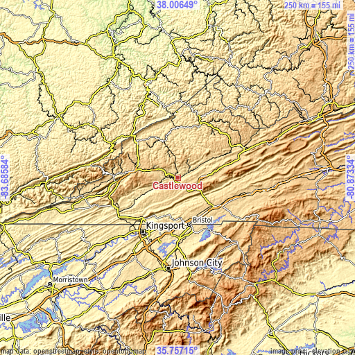
| \ | Map #1 | Topo.Map |
| Scale [m] | 442..793 m | × |
| Scale [ft] | 1450..2602 ft | × |
| Average | 549.2 m = 1802 ft | × |
| Width | 7.82 km = 4.9 mi | 250.1 km = 155.4 mi |
| Height | 7.82 km = 4.9 mi | 250.1 km = 155.4 mi |
| ↑Max Latitude | 36.925239° | 38.00649° |
| Latitude at center | 36.8901° | 36.8901° |
| ↓Min Latitude | 36.854945° | 35.75715° |
| ← Min Longitude | -82.323535° | -83.68584° |
| Longitude center | -82.27959° | -82.27959° |
| →Max Longitude | -82.235645° | -80.87334° |
Nearby cities:
Cities around Castlewood sort by population:
• Bristol elevation 509 m
33.8 km,  166°
166°
• Bristol 513 m
33.6 km, 166°
• Bloomingdale 434 m
38.8 km,  208°
208°
• Abingdon 638 m
33.6 km,  126°
126°
• Norton 652 m
31.4 km,  278°
278°
• Lebanon 627 m
17.8 km,  86°
86°
• Wise 746 m
28 km,  289°
289°
• Fairmount 530 m
35.3 km,  164°
164°
• Walnut Hill 489 m
35.7 km,  176°
176°
• Coeburn 609 m
17.5 km, 290°
• Honaker 581 m
30.5 km,  62°
62°
• Clintwood 538 m
32.9 km,  331°
331°
Multilingual:
 En español:
Castlewood elevación 491 m.
 En France:
Castlewood élévation 491 m.
 Auf Deutsch:
Castlewood höhe über dem Meeresspiegel ist 491 m.

Sources and notes:
- [note 1] Map square and city borders are not equal. Map elevation data is calculated only from area inside that square.
- [src 1] Elevation data from geonames database provided with same terms of usage.
- [src 2] The elevation map of Castlewood is generated using elevation data from NASA's 3 arcsec (90m) resolution SRTM data.
- [src 3] Base (background) map © OpenStreetMap contributors tiles are generated by Geofabrik and OpenTopoMap.
Copyright & License:
This Castlewood Elevation Map is licensed under CC BY-SA. You may reuse any part from this page, if you give a proper credit by linking to this URL:
 More info on terms of use page.