Fairmount elevation
Fairmount (Tennessee, Sullivan County), United States elevation is 530 meters and Fairmount elevation in feet is 1739 ft above sea level [src 1]. Fairmount is a populated place (feature code) with elevation that is 251 meters (823 ft) bigger than average city elevation in United States.
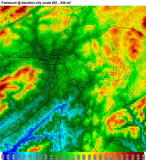
Below is the Elevation map of Fairmount, which displays elevation range with different colors. Scale of the first map is from 452 to 636 m (1483 to 2087 ft) with average elevation of 535.9 meters (=1758 ft) [note 1]
These maps also provides idea of topography and contour of this city, they are displayed at different zoom levels. More info about maps, scale and edge coordinates you can find below images.
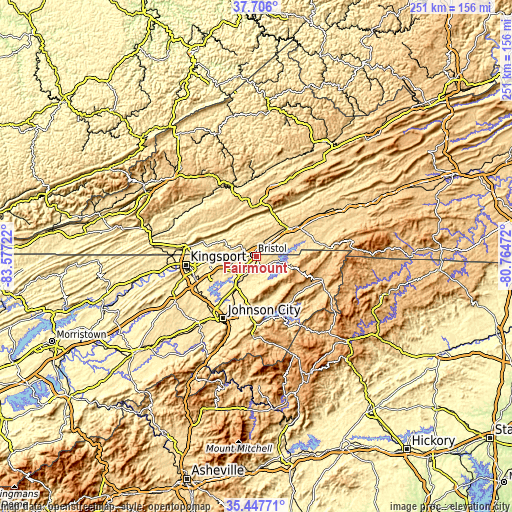
| \ | Map #1 | Topo.Map |
| Scale [m] | 452..636 m | × |
| Scale [ft] | 1483..2087 ft | × |
| Average | 535.9 m = 1758 ft | × |
| Width | 7.85 km = 4.9 mi | 251.1 km = 156 mi |
| Height | 7.85 km = 4.9 mi | 251.1 km = 156 mi |
| ↑Max Latitude | 36.620389° | 37.706° |
| Latitude at center | 36.58511° | 36.58511° |
| ↓Min Latitude | 36.549815° | 35.44771° |
| ← Min Longitude | -82.214915° | -83.57722° |
| Longitude center | -82.17097° | -82.17097° |
| →Max Longitude | -82.127025° | -80.76472° |
Nearby cities:
Cities around Fairmount sort by population:
• Bristol elevation 509 m
1.9 km,  305°
305°
• Bristol 513 m
2 km, 309°
• Elizabethton 467 m
26.5 km,  187°
187°
• Bloomingdale 434 m
28.4 km,  269°
269°
• Abingdon 638 m
22.2 km,  51°
51°
• Oak Grove 431 m
29.8 km,  229°
229°
• Spurgeon 443 m
30.2 km,  237°
237°
• Blountville 469 m
15.1 km,  247°
247°
• Walnut Hill 489 m
7.8 km,  257°
257°
• Central 506 m
30.7 km,  200°
200°
• Hunter 479 m
23.7 km,  177°
177°
• Bluff City 444 m
14.7 km,  213°
213°
Multilingual:
 En español:
Fairmount elevación 530 m.
 En France:
Fairmount élévation 530 m.
 Auf Deutsch:
Fairmount höhe über dem Meeresspiegel ist 530 m.

Sources and notes:
- [note 1] Map square and city borders are not equal. Map elevation data is calculated only from area inside that square.
- [src 1] Elevation data from geonames database provided with same terms of usage.
- [src 2] The elevation map of Fairmount is generated using elevation data from NASA's 3 arcsec (90m) resolution SRTM data.
- [src 3] Base (background) map © OpenStreetMap contributors tiles are generated by Geofabrik and OpenTopoMap.
Copyright & License:
This Fairmount Elevation Map is licensed under CC BY-SA. You may reuse any part from this page, if you give a proper credit by linking to this URL:
 More info on terms of use page.