Louisa elevation
Louisa (Virginia, Louisa County), United States elevation is 139 meters and Louisa elevation in feet is 456 ft above sea level [src 1]. Louisa is a seat of a second-order administrative division (feature code) with elevation that is 140 meters (459 ft) smaller than average city elevation in United States.
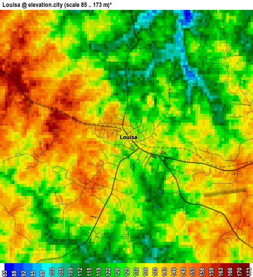
Below is the Elevation map of Louisa, which displays elevation range with different colors. Scale of the first map is from 85 to 173 m (279 to 568 ft) with average elevation of 133.3 meters (=437 ft) [note 1]
These maps also provides idea of topography and contour of this city, they are displayed at different zoom levels. More info about maps, scale and edge coordinates you can find below images.
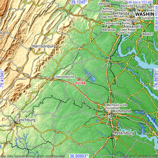
| \ | Map #1 | Topo.Map |
| Scale [m] | 85..173 m | × |
| Scale [ft] | 279..568 ft | × |
| Average | 133.3 m = 437 ft | × |
| Width | 7.7 km = 4.8 mi | 246.3 km = 153 mi |
| Height | 7.7 km = 4.8 mi | 246.3 km = 153 mi |
| ↑Max Latitude | 38.059749° | 39.1245° |
| Latitude at center | 38.02514° | 38.02514° |
| ↓Min Latitude | 37.990514° | 36.90903° |
| ← Min Longitude | -78.048105° | -79.41041° |
| Longitude center | -78.00416° | -78.00416° |
| →Max Longitude | -77.960215° | -76.59791° |
Nearby cities:
Cities around Louisa sort by population:
• Charlottesville elevation 141 m
41.4 km,  270°
270°
• Lake Monticello 120 m
31.1 km,  248°
248°
• Hollymead 151 m
39.6 km,  284°
284°
• Orange 165 m
26.2 km,  339°
339°
• Spotsylvania Courthouse 96 m
41.2 km,  62°
62°
• Pantops 110 m
39.5 km, 271°
• Gordonsville 149 m
20.3 km,  307°
307°
• Weber City 146 m
38.8 km,  219°
219°
• Ruckersville 189 m
39.4 km, 305°
• Goochland 78 m
39.3 km,  164°
164°
• Palmyra 91 m
29.1 km,  231°
231°
• Spotsylvania 94 m
41.2 km, 61°
Multilingual:
 En español:
Louisa elevación 139 m.
 En France:
Louisa élévation 139 m.


Sources and notes:
- [note 1] Map square and city borders are not equal. Map elevation data is calculated only from area inside that square.
- [src 1] Elevation data from geonames database provided with same terms of usage.
- [src 2] The elevation map of Louisa is generated using elevation data from NASA's 3 arcsec (90m) resolution SRTM data.
- [src 3] Base (background) map © OpenStreetMap contributors tiles are generated by Geofabrik and OpenTopoMap.
Copyright & License:
This Louisa Elevation Map is licensed under CC BY-SA. You may reuse any part from this page, if you give a proper credit by linking to this URL:
 More info on terms of use page.