Pantops elevation
Pantops (Virginia, Albemarle County), United States elevation is 110 meters and Pantops elevation in feet is 361 ft above sea level [src 1]. Pantops is a populated place (feature code) with elevation that is 169 meters (554 ft) smaller than average city elevation in United States.
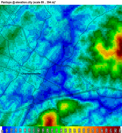
Below is the Elevation map of Pantops, which displays elevation range with different colors. Scale of the first map is from 89 to 394 m (292 to 1293 ft) with average elevation of 151.3 meters (=496 ft) [note 1]
These maps also provides idea of topography and contour of this city, they are displayed at different zoom levels. More info about maps, scale and edge coordinates you can find below images.
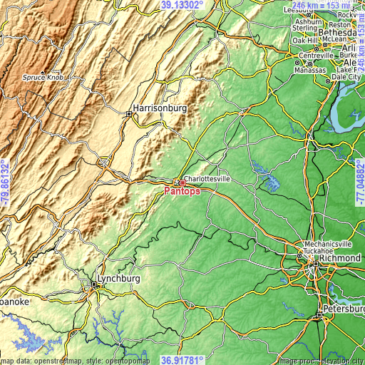
| \ | Map #1 | Topo.Map |
| Scale [m] | 89..394 m | × |
| Scale [ft] | 292..1293 ft | × |
| Average | 151.3 m = 496 ft | × |
| Width | 7.7 km = 4.8 mi | 246.3 km = 153 mi |
| Height | 7.7 km = 4.8 mi | 246.3 km = 153 mi |
| ↑Max Latitude | 38.068395° | 39.13302° |
| Latitude at center | 38.03379° | 38.03379° |
| ↓Min Latitude | 37.999168° | 36.91781° |
| ← Min Longitude | -78.499015° | -79.86132° |
| Longitude center | -78.45507° | -78.45507° |
| →Max Longitude | -78.411125° | -77.04882° |
Nearby cities:
Cities around Pantops sort by population:
• Charlottesville elevation 141 m
2 km,  255°
255°
• Lake Monticello 120 m
16.2 km,  139°
139°
• Hollymead 151 m
9.3 km,  7°
7°
• Crozet 217 m
21.9 km,  280°
280°
• Crimora 380 m
37.1 km,  291°
291°
• Twin Lakes 178 m
24 km,  2°
2°
• Gordonsville 149 m
26.1 km,  63°
63°
• Dooms 384 m
36.2 km, 283°
• Weber City 146 m
34.4 km,  154°
154°
• Ruckersville 189 m
23.4 km,  18°
18°
• Stanardsville 202 m
29.3 km, 2°
• Palmyra 91 m
25.5 km, 138°
Multilingual:
 En español:
Pantops elevación 110 m.
 En France:
Pantops élévation 110 m.


Sources and notes:
- [note 1] Map square and city borders are not equal. Map elevation data is calculated only from area inside that square.
- [src 1] Elevation data from geonames database provided with same terms of usage.
- [src 2] The elevation map of Pantops is generated using elevation data from NASA's 3 arcsec (90m) resolution SRTM data.
- [src 3] Base (background) map © OpenStreetMap contributors tiles are generated by Geofabrik and OpenTopoMap.
Copyright & License:
This Pantops Elevation Map is licensed under CC BY-SA. You may reuse any part from this page, if you give a proper credit by linking to this URL:
 More info on terms of use page.