Charlottesville elevation
Charlottesville (Virginia, City of Charlottesville), United States elevation is 141 meters and Charlottesville elevation in feet is 463 ft above sea level [src 1]. Charlottesville is a seat of a second-order administrative division (feature code) with elevation that is 138 meters (453 ft) smaller than average city elevation in United States.
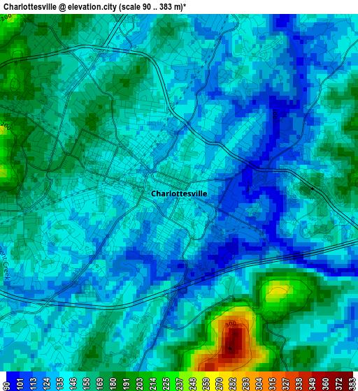
Below is the Elevation map of Charlottesville, which displays elevation range with different colors. Scale of the first map is from 90 to 383 m (295 to 1257 ft) with average elevation of 149.1 meters (=489 ft) [note 1]
These maps also provides idea of topography and contour of this city, they are displayed at different zoom levels. More info about maps, scale and edge coordinates you can find below images.
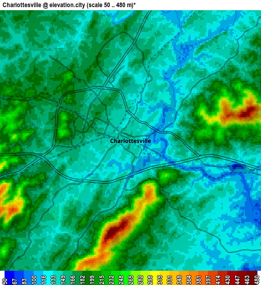
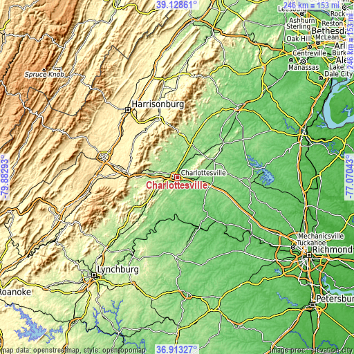
| \ | Map #1 | Map #2 | Topo.Map |
| Scale [m] | 90..383 m | 50..480 m | × |
| Scale [ft] | 295..1257 ft | 164..1575 ft | × |
| Average | 149.1 m = 489 ft | 166.1 m = 545 ft | × |
| Width | 7.7 km = 4.8 mi | 15.4 km = 9.6 mi | 246.3 km = 153 mi |
| Height | 7.7 km = 4.8 mi | 15.4 km = 9.6 mi | 246.3 km = 153 mi |
| ↑Max Latitude | 38.063917° | 38.098508° | 39.12861° |
| Latitude at center | 38.02931° | 38.02931° | 38.02931° |
| ↓Min Latitude | 37.994686° | 37.960046° | 36.91327° |
| ← Min Longitude | -78.520625° | -78.564571° | -79.88293° |
| Longitude center | -78.47668° | -78.47668° | -78.47668° |
| →Max Longitude | -78.432735° | -78.388789° | -77.07043° |
Nearby cities:
Cities around Charlottesville sort by population:
• Lake Monticello elevation 120 m
17.1 km,  133°
133°
• Hollymead 151 m
10.2 km,  17°
17°
• Crozet 217 m
20.1 km,  282°
282°
• Pantops 110 m
2 km,  75°
75°
• Crimora 380 m
35.5 km,  292°
292°
• Twin Lakes 178 m
24.6 km,  6°
6°
• Gordonsville 149 m
28 km,  64°
64°
• Dooms 384 m
34.5 km, 284°
• Weber City 146 m
34.9 km,  150°
150°
• Ruckersville 189 m
24.5 km, 22°
• Stanardsville 202 m
30 km, 6°
• Palmyra 91 m
26.5 km,  135°
135°
Multilingual:
 En español:
Charlottesville elevación 141 m.
 En France:
Charlottesville élévation 141 m.
 Auf Deutsch:
Charlottesville höhe über dem Meeresspiegel ist 141 m.
 На русском:
Шарлоттсвилль, Шарлотсвилл высота над уровнем моря 141 м
Sources and notes:
- [note 1] Map square and city borders are not equal. Map elevation data is calculated only from area inside that square.
- [src 1] Elevation data from geonames database provided with same terms of usage.
- [src 2] The elevation map of Charlottesville is generated using elevation data from NASA's 3 arcsec (90m) resolution SRTM data.
- [src 3] Base (background) map © OpenStreetMap contributors tiles are generated by Geofabrik and OpenTopoMap.
Copyright & License:
This Charlottesville Elevation Map is licensed under CC BY-SA. You may reuse any part from this page, if you give a proper credit by linking to this URL:
 More info on terms of use page.