Goochland elevation
Goochland (Virginia, Goochland County), United States elevation is 78 meters and Goochland elevation in feet is 256 ft above sea level [src 1]. Goochland is a seat of a second-order administrative division (feature code) with elevation that is 201 meters (659 ft) smaller than average city elevation in United States.
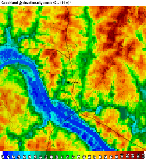
Below is the Elevation map of Goochland, which displays elevation range with different colors. Scale of the first map is from 42 to 111 m (138 to 364 ft) with average elevation of 78.9 meters (=259 ft) [note 1]
These maps also provides idea of topography and contour of this city, they are displayed at different zoom levels. More info about maps, scale and edge coordinates you can find below images.
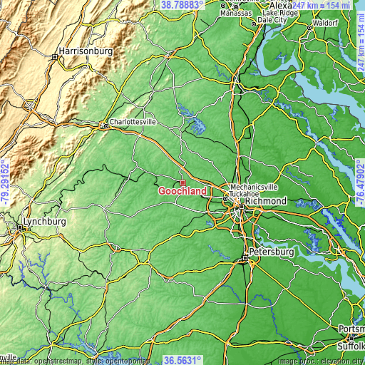
| \ | Map #1 | Topo.Map |
| Scale [m] | 42..111 m | × |
| Scale [ft] | 138..364 ft | × |
| Average | 78.9 m = 259 ft | × |
| Width | 7.73 km = 4.8 mi | 247.5 km = 153.8 mi |
| Height | 7.73 km = 4.8 mi | 247.5 km = 153.8 mi |
| ↑Max Latitude | 37.71908° | 38.78883° |
| Latitude at center | 37.68431° | 37.68431° |
| ↓Min Latitude | 37.649524° | 36.5631° |
| ← Min Longitude | -77.929215° | -79.29152° |
| Longitude center | -77.88527° | -77.88527° |
| →Max Longitude | -77.841325° | -76.47902° |
Nearby cities:
Cities around Goochland sort by population:
• Tuckahoe elevation 80 m
30.8 km,  109°
109°
• Short Pump 88 m
24.3 km,  98°
98°
• Laurel 72 m
33.4 km, 97°
• Bon Air 101 m
33.9 km,  121°
121°
• Glen Allen 61 m
33.4 km,  93°
93°
• Brandermill 74 m
34.9 km,  143°
143°
• Wyndham 71 m
24.1 km, 86°
• Dumbarton 66 m
35.8 km, 104°
• Ashland 67 m
36.6 km,  76°
76°
• Woodlake 80 m
34.4 km,  148°
148°
• Weber City 146 m
35.9 km,  282°
282°
• Powhatan 120 m
16.1 km,  190°
190°
Multilingual:
 En español:
Goochland elevación 78 m.
 En France:
Goochland élévation 78 m.
 Auf Deutsch:
Goochland höhe über dem Meeresspiegel ist 78 m.

Sources and notes:
- [note 1] Map square and city borders are not equal. Map elevation data is calculated only from area inside that square.
- [src 1] Elevation data from geonames database provided with same terms of usage.
- [src 2] The elevation map of Goochland is generated using elevation data from NASA's 3 arcsec (90m) resolution SRTM data.
- [src 3] Base (background) map © OpenStreetMap contributors tiles are generated by Geofabrik and OpenTopoMap.
Copyright & License:
This Goochland Elevation Map is licensed under CC BY-SA. You may reuse any part from this page, if you give a proper credit by linking to this URL:
 More info on terms of use page.