Laurel elevation
Laurel (Virginia, Henrico County), United States elevation is 72 meters and Laurel elevation in feet is 236 ft above sea level [src 1]. Laurel is a populated place (feature code) with elevation that is 207 meters (679 ft) smaller than average city elevation in United States.
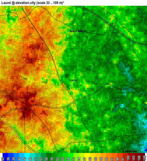
Below is the Elevation map of Laurel, which displays elevation range with different colors. Scale of the first map is from 33 to 109 m (108 to 358 ft) with average elevation of 73.1 meters (=240 ft) [note 1]
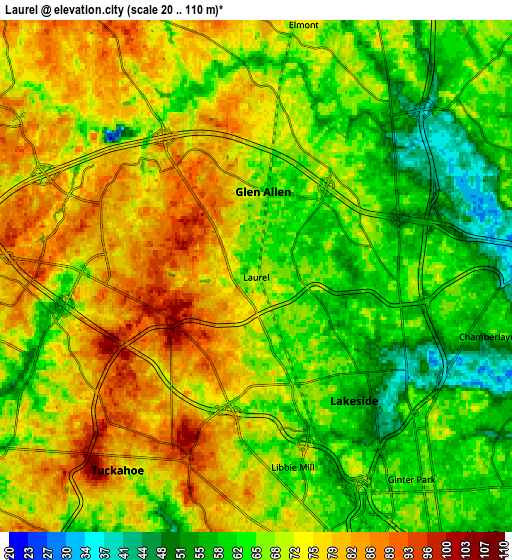
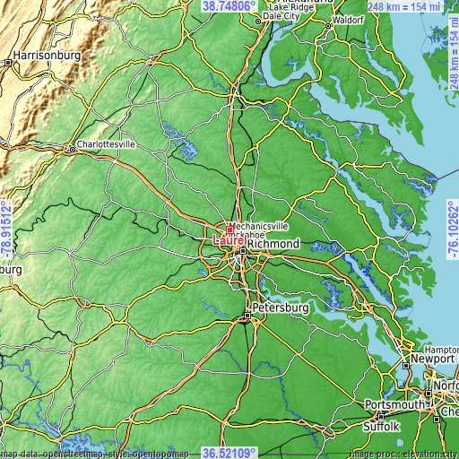
These maps also provides idea of topography and contour of this city, they are displayed at different zoom levels. More info about maps, scale and edge coordinates you can find below images.
| \ | Map #1 | Map #2 | Topo.Map |
| Scale [m] | 33..109 m | 20..110 m | × |
| Scale [ft] | 108..358 ft | 66..361 ft | × |
| Average | 73.1 m = 240 ft | 69.6 m = 228 ft | × |
| Width | 7.74 km = 4.8 mi | 15.48 km = 9.6 mi | 247.6 km = 153.9 mi |
| Height | 7.74 km = 4.8 mi | 15.48 km = 9.6 mi | 247.6 km = 153.9 mi |
| ↑Max Latitude | 37.677709° | 37.712482° | 38.74806° |
| Latitude at center | 37.64292° | 37.64292° | 37.64292° |
| ↓Min Latitude | 37.608115° | 37.573293° | 36.52109° |
| ← Min Longitude | -77.552815° | -77.596761° | -78.91512° |
| Longitude center | -77.50887° | -77.50887° | -77.50887° |
| →Max Longitude | -77.464925° | -77.420979° | -76.10262° |
Nearby cities:
Cities around Laurel sort by population:
• Richmond elevation 68 m
10.8 km,  156°
156°
• Tuckahoe 80 m
7.2 km,  215°
215°
• Mechanicsville 50 m
12.5 km,  107°
107°
• Short Pump 88 m
9.2 km,  275°
275°
• Bon Air 101 m
13.8 km,  198°
198°
• East Highland Park 62 m
11.3 km,  127°
127°
• Glen Allen 61 m
2.6 km,  4°
4°
• Lakeside 58 m
4.8 km,  144°
144°
• Wyndham 71 m
11 km,  304°
304°
• Dumbarton 66 m
4.6 km, 160°
• Ashland 67 m
13.2 km,  11°
11°
• Chamberlayne 61 m
7.3 km,  104°
104°
Multilingual:
 En español:
Laurel elevación 72 m.
 En France:
Laurel élévation 72 m.


Sources and notes:
- [note 1] Map square and city borders are not equal. Map elevation data is calculated only from area inside that square.
- [src 1] Elevation data from geonames database provided with same terms of usage.
- [src 2] The elevation map of Laurel is generated using elevation data from NASA's 3 arcsec (90m) resolution SRTM data.
- [src 3] Base (background) map © OpenStreetMap contributors tiles are generated by Geofabrik and OpenTopoMap.
Copyright & License:
This Laurel Elevation Map is licensed under CC BY-SA. You may reuse any part from this page, if you give a proper credit by linking to this URL:
 More info on terms of use page.