Farmville elevation
Farmville (Virginia, Prince Edward County), United States elevation is 97 meters and Farmville elevation in feet is 318 ft above sea level [src 1]. Farmville is a seat of a second-order administrative division (feature code) with elevation that is 182 meters (597 ft) smaller than average city elevation in United States.
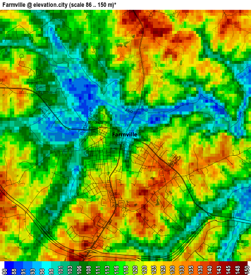
Below is the Elevation map of Farmville, which displays elevation range with different colors. Scale of the first map is from 86 to 150 m (282 to 492 ft) with average elevation of 116.7 meters (=383 ft) [note 1]
These maps also provides idea of topography and contour of this city, they are displayed at different zoom levels. More info about maps, scale and edge coordinates you can find below images.
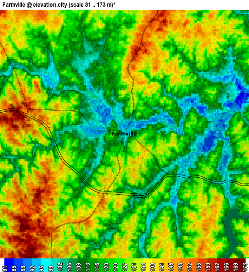
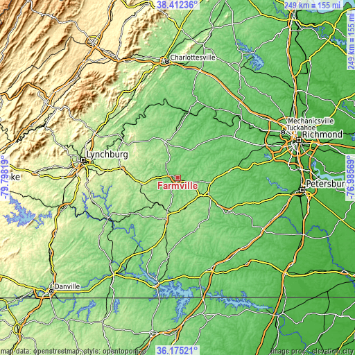
| \ | Map #1 | Map #2 | Topo.Map |
| Scale [m] | 86..150 m | 81..173 m | × |
| Scale [ft] | 282..492 ft | 266..568 ft | × |
| Average | 116.7 m = 383 ft | 124.5 m = 408 ft | × |
| Width | 7.77 km = 4.8 mi | 15.55 km = 9.7 mi | 248.7 km = 154.5 mi |
| Height | 7.77 km = 4.8 mi | 15.55 km = 9.7 mi | 248.7 km = 154.5 mi |
| ↑Max Latitude | 37.337048° | 37.37198° | 38.41236° |
| Latitude at center | 37.3021° | 37.3021° | 37.3021° |
| ↓Min Latitude | 37.267136° | 37.232155° | 36.17521° |
| ← Min Longitude | -78.435885° | -78.479831° | -79.79819° |
| Longitude center | -78.39194° | -78.39194° | -78.39194° |
| →Max Longitude | -78.347995° | -78.304049° | -76.98569° |
Nearby cities:
Cities around Farmville sort by population:
• Blackstone elevation 133 m
42.8 km,  125°
125°
• Crewe 153 m
27.8 km,  121°
121°
• Appomattox 257 m
38.8 km,  279°
279°
• Victoria 172 m
37.1 km,  156°
156°
• Hampden Sydney 164 m
8.9 km,  222°
222°
• Kenbridge 148 m
44.6 km,  147°
147°
• Amelia Court House 117 m
36.7 km,  82°
82°
• Charlotte Court House 182 m
35 km, 218°
• Cumberland 143 m
25.2 km,  31°
31°
• Lunenburg 153 m
39.5 km, 163°
• Powhatan 120 m
49.6 km,  57°
57°
• Buckingham 137 m
31.1 km,  332°
332°
Multilingual:
 En español:
Farmville elevación 97 m.
 En France:
Farmville élévation 97 m.
 Auf Deutsch:
Farmville höhe über dem Meeresspiegel ist 97 m.

Sources and notes:
- [note 1] Map square and city borders are not equal. Map elevation data is calculated only from area inside that square.
- [src 1] Elevation data from geonames database provided with same terms of usage.
- [src 2] The elevation map of Farmville is generated using elevation data from NASA's 3 arcsec (90m) resolution SRTM data.
- [src 3] Base (background) map © OpenStreetMap contributors tiles are generated by Geofabrik and OpenTopoMap.
Copyright & License:
This Farmville Elevation Map is licensed under CC BY-SA. You may reuse any part from this page, if you give a proper credit by linking to this URL:
 More info on terms of use page.