Appomattox elevation
Appomattox (Virginia, Appomattox County), United States elevation is 257 meters and Appomattox elevation in feet is 843 ft above sea level [src 1]. Appomattox is a seat of a second-order administrative division (feature code) with elevation that is 22 meters (72 ft) smaller than average city elevation in United States.
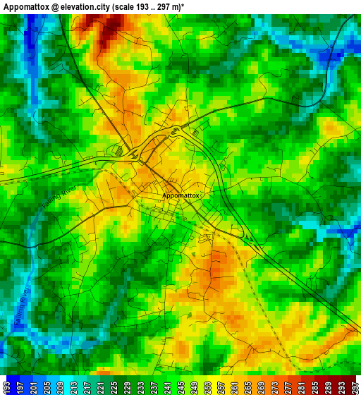
Below is the Elevation map of Appomattox, which displays elevation range with different colors. Scale of the first map is from 193 to 297 m (633 to 974 ft) with average elevation of 239.5 meters (=786 ft) [note 1]
These maps also provides idea of topography and contour of this city, they are displayed at different zoom levels. More info about maps, scale and edge coordinates you can find below images.
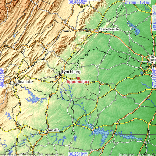
| \ | Map #1 | Topo.Map |
| Scale [m] | 193..297 m | × |
| Scale [ft] | 633..974 ft | × |
| Average | 239.5 m = 786 ft | × |
| Width | 7.77 km = 4.8 mi | 248.6 km = 154.5 mi |
| Height | 7.77 km = 4.8 mi | 248.6 km = 154.5 mi |
| ↑Max Latitude | 37.392013° | 38.46652° |
| Latitude at center | 37.35709° | 37.35709° |
| ↓Min Latitude | 37.322151° | 36.23101° |
| ← Min Longitude | -78.869235° | -80.23154° |
| Longitude center | -78.82529° | -78.82529° |
| →Max Longitude | -78.781345° | -77.41904° |
Nearby cities:
Cities around Appomattox sort by population:
• Lynchburg elevation 199 m
28.7 km,  282°
282°
• West Lynchburg 225 m
31.6 km, 279°
• Timberlake 282 m
38.4 km,  263°
263°
• Madison Heights 230 m
27.6 km,  287°
287°
• Farmville 97 m
38.8 km,  99°
99°
• Amherst 229 m
32.3 km,  321°
321°
• Concord 268 m
13.3 km, 263°
• Hampden Sydney 164 m
34.8 km,  111°
111°
• Rustburg 267 m
26 km,  249°
249°
• Brookneal 168 m
35.7 km,  197°
197°
• Charlotte Court House 182 m
37.3 km,  153°
153°
• Buckingham 137 m
32.1 km,  47°
47°
Multilingual:
 En español:
Appomattox elevación 257 m.
 En France:
Appomattox élévation 257 m.
 Auf Deutsch:
Appomattox höhe über dem Meeresspiegel ist 257 m.

Sources and notes:
- [note 1] Map square and city borders are not equal. Map elevation data is calculated only from area inside that square.
- [src 1] Elevation data from geonames database provided with same terms of usage.
- [src 2] The elevation map of Appomattox is generated using elevation data from NASA's 3 arcsec (90m) resolution SRTM data.
- [src 3] Base (background) map © OpenStreetMap contributors tiles are generated by Geofabrik and OpenTopoMap.
Copyright & License:
This Appomattox Elevation Map is licensed under CC BY-SA. You may reuse any part from this page, if you give a proper credit by linking to this URL:
 More info on terms of use page.