Brookneal elevation
Brookneal (Virginia, Campbell County), United States elevation is 168 meters and Brookneal elevation in feet is 551 ft above sea level [src 1]. Brookneal is a populated place (feature code) with elevation that is 111 meters (364 ft) smaller than average city elevation in United States.
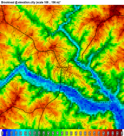
Below is the Elevation map of Brookneal, which displays elevation range with different colors. Scale of the first map is from 108 to 196 m (354 to 643 ft) with average elevation of 154.8 meters (=508 ft) [note 1]
These maps also provides idea of topography and contour of this city, they are displayed at different zoom levels. More info about maps, scale and edge coordinates you can find below images.

| \ | Map #1 | Topo.Map |
| Scale [m] | 108..196 m | × |
| Scale [ft] | 354..643 ft | × |
| Average | 154.8 m = 508 ft | × |
| Width | 7.8 km = 4.8 mi | 249.6 km = 155.1 mi |
| Height | 7.8 km = 4.8 mi | 249.6 km = 155.1 mi |
| ↑Max Latitude | 37.085205° | 38.16415° |
| Latitude at center | 37.05014° | 37.05014° |
| ↓Min Latitude | 37.015059° | 35.91953° |
| ← Min Longitude | -78.988125° | -80.35043° |
| Longitude center | -78.94418° | -78.94418° |
| →Max Longitude | -78.900235° | -77.53793° |
Nearby cities:
Cities around Brookneal sort by population:
• Timberlake elevation 282 m
40.9 km,  317°
317°
• South Boston 122 m
39.3 km,  174°
174°
• Altavista 163 m
31.1 km,  282°
282°
• Appomattox 257 m
35.7 km,  17°
17°
• Concord 268 m
32.6 km,  355°
355°
• Rustburg 267 m
28.8 km,  331°
331°
• Hurt 222 m
31.6 km, 278°
• Halifax 141 m
31.6 km,  177°
177°
• Gretna 256 m
38.4 km,  253°
253°
• Mountain Road 166 m
32.5 km,  186°
186°
• Motley 242 m
35.3 km,  273°
273°
• Charlotte Court House 182 m
27.1 km,  88°
88°
Multilingual:
 En español:
Brookneal elevación 168 m.
 En France:
Brookneal élévation 168 m.
 Auf Deutsch:
Brookneal höhe über dem Meeresspiegel ist 168 m.

Sources and notes:
- [note 1] Map square and city borders are not equal. Map elevation data is calculated only from area inside that square.
- [src 1] Elevation data from geonames database provided with same terms of usage.
- [src 2] The elevation map of Brookneal is generated using elevation data from NASA's 3 arcsec (90m) resolution SRTM data.
- [src 3] Base (background) map © OpenStreetMap contributors tiles are generated by Geofabrik and OpenTopoMap.
Copyright & License:
This Brookneal Elevation Map is licensed under CC BY-SA. You may reuse any part from this page, if you give a proper credit by linking to this URL:
 More info on terms of use page.