Mountain Road elevation
Mountain Road (Virginia, Halifax County), United States elevation is 166 meters and Mountain Road elevation in feet is 545 ft above sea level [src 1]. Mountain Road is a populated place (feature code) with elevation that is 113 meters (371 ft) smaller than average city elevation in United States.
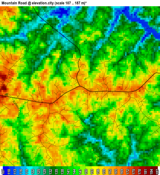
Below is the Elevation map of Mountain Road, which displays elevation range with different colors. Scale of the first map is from 107 to 187 m (351 to 614 ft) with average elevation of 145 meters (=476 ft) [note 1]
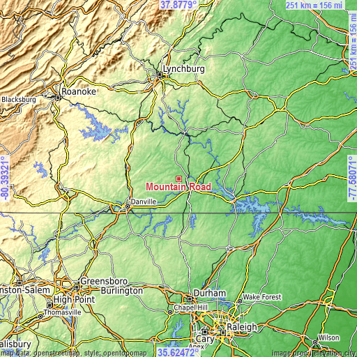
These maps also provides idea of topography and contour of this city, they are displayed at different zoom levels. More info about maps, scale and edge coordinates you can find below images.
| \ | Map #1 | Topo.Map |
| Scale [m] | 107..187 m | × |
| Scale [ft] | 351..614 ft | × |
| Average | 145 m = 476 ft | × |
| Width | 7.83 km = 4.9 mi | 250.5 km = 155.7 mi |
| Height | 7.83 km = 4.9 mi | 250.5 km = 155.7 mi |
| ↑Max Latitude | 36.794779° | 37.8779° |
| Latitude at center | 36.75958° | 36.75958° |
| ↓Min Latitude | 36.724365° | 35.62472° |
| ← Min Longitude | -79.030905° | -80.39321° |
| Longitude center | -78.98696° | -78.98696° |
| →Max Longitude | -78.943015° | -77.58071° |
Nearby cities:
Cities around Mountain Road sort by population:
• Danville elevation 157 m
41.2 km,  242°
242°
• Roxboro 220 m
40.7 km,  179°
179°
• South Boston 122 m
10.2 km,  131°
131°
• Mount Hermon 210 m
39.8 km,  256°
256°
• Chatham 224 m
37.3 km,  281°
281°
• Hurt 222 m
46.1 km,  323°
323°
• Halifax 141 m
5.3 km,  82°
82°
• Gretna 256 m
39.5 km,  303°
303°
• Clarksville 108 m
41.2 km,  111°
111°
• Brookneal 168 m
32.5 km,  6°
6°
• Motley 242 m
46.7 km, 317°
• Charlotte Court House 182 m
45.3 km,  43°
43°
Multilingual:
 En español:
Mountain Road elevación 166 m.
 En France:
Mountain Road élévation 166 m.
 Auf Deutsch:
Mountain Road höhe über dem Meeresspiegel ist 166 m.

Sources and notes:
- [note 1] Map square and city borders are not equal. Map elevation data is calculated only from area inside that square.
- [src 1] Elevation data from geonames database provided with same terms of usage.
- [src 2] The elevation map of Mountain Road is generated using elevation data from NASA's 3 arcsec (90m) resolution SRTM data.
- [src 3] Base (background) map © OpenStreetMap contributors tiles are generated by Geofabrik and OpenTopoMap.
Copyright & License:
This Mountain Road Elevation Map is licensed under CC BY-SA. You may reuse any part from this page, if you give a proper credit by linking to this URL:
 More info on terms of use page.