Crewe elevation
Crewe (Virginia, Nottoway County), United States elevation is 153 meters and Crewe elevation in feet is 502 ft above sea level [src 1]. Crewe is a populated place (feature code) with elevation that is 126 meters (413 ft) smaller than average city elevation in United States.
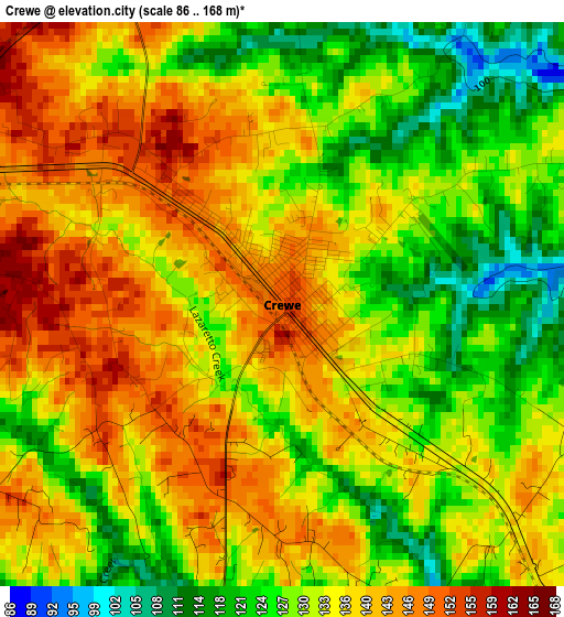
Below is the Elevation map of Crewe, which displays elevation range with different colors. Scale of the first map is from 86 to 168 m (282 to 551 ft) with average elevation of 133.8 meters (=439 ft) [note 1]
These maps also provides idea of topography and contour of this city, they are displayed at different zoom levels. More info about maps, scale and edge coordinates you can find below images.
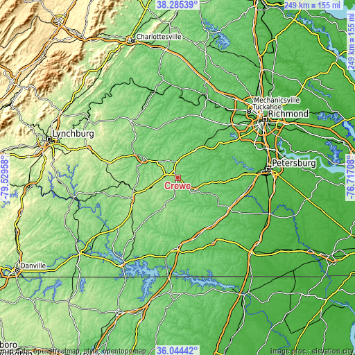
| \ | Map #1 | Topo.Map |
| Scale [m] | 86..168 m | × |
| Scale [ft] | 282..551 ft | × |
| Average | 133.8 m = 439 ft | × |
| Width | 7.79 km = 4.8 mi | 249.2 km = 154.8 mi |
| Height | 7.79 km = 4.8 mi | 249.2 km = 154.8 mi |
| ↑Max Latitude | 37.208218° | 38.28539° |
| Latitude at center | 37.17321° | 37.17321° |
| ↓Min Latitude | 37.138186° | 36.04442° |
| ← Min Longitude | -78.167275° | -79.52958° |
| Longitude center | -78.12333° | -78.12333° |
| →Max Longitude | -78.079385° | -76.71708° |
Nearby cities:
Cities around Crewe sort by population:
• Farmville elevation 97 m
27.8 km,  301°
301°
• Woodlake 80 m
48 km,  54°
54°
• Blackstone 133 m
15.2 km,  132°
132°
• Victoria 172 m
21.9 km,  204°
204°
• Hampden Sydney 164 m
30.8 km,  284°
284°
• Kenbridge 148 m
23.5 km,  180°
180°
• Amelia Court House 117 m
22.7 km,  33°
33°
• Charlotte Court House 182 m
47.5 km,  254°
254°
• Cumberland 143 m
37.5 km,  343°
343°
• Lunenburg 153 m
26.8 km,  208°
208°
• Dinwiddie 82 m
48.7 km,  102°
102°
• Powhatan 120 m
44.8 km,  23°
23°
Multilingual:
 En español:
Crewe elevación 153 m.
 En France:
Crewe élévation 153 m.


Sources and notes:
- [note 1] Map square and city borders are not equal. Map elevation data is calculated only from area inside that square.
- [src 1] Elevation data from geonames database provided with same terms of usage.
- [src 2] The elevation map of Crewe is generated using elevation data from NASA's 3 arcsec (90m) resolution SRTM data.
- [src 3] Base (background) map © OpenStreetMap contributors tiles are generated by Geofabrik and OpenTopoMap.
Copyright & License:
This Crewe Elevation Map is licensed under CC BY-SA. You may reuse any part from this page, if you give a proper credit by linking to this URL:
 More info on terms of use page.