Cumberland elevation
Cumberland (Virginia, Cumberland County), United States elevation is 143 meters and Cumberland elevation in feet is 469 ft above sea level [src 1]. Cumberland is a seat of a second-order administrative division (feature code) with elevation that is 136 meters (446 ft) smaller than average city elevation in United States.
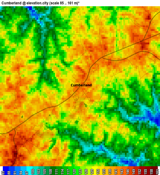
Below is the Elevation map of Cumberland, which displays elevation range with different colors. Scale of the first map is from 85 to 161 m (279 to 528 ft) with average elevation of 126.7 meters (=416 ft) [note 1]
These maps also provides idea of topography and contour of this city, they are displayed at different zoom levels. More info about maps, scale and edge coordinates you can find below images.
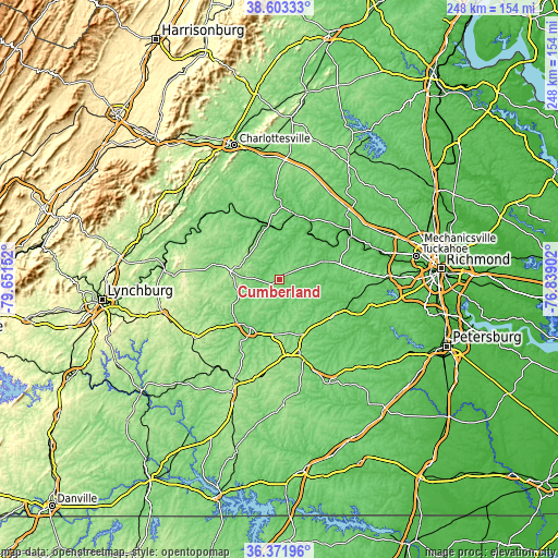
| \ | Map #1 | Topo.Map |
| Scale [m] | 85..161 m | × |
| Scale [ft] | 279..528 ft | × |
| Average | 126.7 m = 416 ft | × |
| Width | 7.75 km = 4.8 mi | 248.1 km = 154.2 mi |
| Height | 7.75 km = 4.8 mi | 248.1 km = 154.2 mi |
| ↑Max Latitude | 37.530838° | 38.60333° |
| Latitude at center | 37.49598° | 37.49598° |
| ↓Min Latitude | 37.461106° | 36.37196° |
| ← Min Longitude | -78.289215° | -79.65152° |
| Longitude center | -78.24527° | -78.24527° |
| →Max Longitude | -78.201325° | -76.83902° |
Nearby cities:
Cities around Cumberland sort by population:
• Lake Monticello elevation 120 m
48.1 km,  350°
350°
• Farmville 97 m
25.2 km,  211°
211°
• Woodlake 80 m
50.6 km,  99°
99°
• Blackstone 133 m
51.2 km,  154°
154°
• Crewe 153 m
37.5 km,  163°
163°
• Hampden Sydney 164 m
34 km, 213°
• Weber City 146 m
29 km, 353°
• Amelia Court House 117 m
28.9 km,  126°
126°
• Goochland 78 m
38 km,  56°
56°
• Palmyra 91 m
40.6 km,  357°
357°
• Powhatan 120 m
29.2 km,  79°
79°
• Buckingham 137 m
28 km,  282°
282°
Multilingual:
 En español:
Cumberland elevación 143 m.
 En France:
Cumberland élévation 143 m.
 Auf Deutsch:
Cumberland höhe über dem Meeresspiegel ist 143 m.

Sources and notes:
- [note 1] Map square and city borders are not equal. Map elevation data is calculated only from area inside that square.
- [src 1] Elevation data from geonames database provided with same terms of usage.
- [src 2] The elevation map of Cumberland is generated using elevation data from NASA's 3 arcsec (90m) resolution SRTM data.
- [src 3] Base (background) map © OpenStreetMap contributors tiles are generated by Geofabrik and OpenTopoMap.
Copyright & License:
This Cumberland Elevation Map is licensed under CC BY-SA. You may reuse any part from this page, if you give a proper credit by linking to this URL:
 More info on terms of use page.