Thorndale elevation
Thorndale (Texas, Milam County), United States elevation is 141 meters and Thorndale elevation in feet is 463 ft above sea level [src 1]. Thorndale is a populated place (feature code) with elevation that is 138 meters (453 ft) smaller than average city elevation in United States.
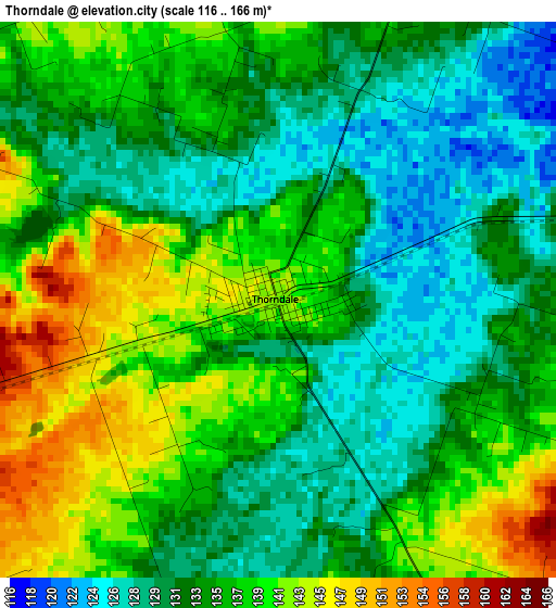
Below is the Elevation map of Thorndale, which displays elevation range with different colors. Scale of the first map is from 116 to 166 m (381 to 545 ft) with average elevation of 135.2 meters (=444 ft) [note 1]
These maps also provides idea of topography and contour of this city, they are displayed at different zoom levels. More info about maps, scale and edge coordinates you can find below images.
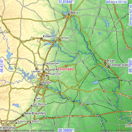
| \ | Map #1 | Topo.Map |
| Scale [m] | 116..166 m | × |
| Scale [ft] | 381..545 ft | × |
| Average | 135.2 m = 444 ft | × |
| Width | 8.41 km = 5.2 mi | 269.1 km = 167.2 mi |
| Height | 8.41 km = 5.2 mi | 269.1 km = 167.2 mi |
| ↑Max Latitude | 30.651623° | 31.81644° |
| Latitude at center | 30.61381° | 30.61381° |
| ↓Min Latitude | 30.575982° | 29.39606° |
| ← Min Longitude | -97.249495° | -98.6118° |
| Longitude center | -97.20555° | -97.20555° |
| →Max Longitude | -97.161605° | -95.7993° |
Nearby cities:
Cities around Thorndale sort by population:
• Hutto elevation 203 m
33.6 km,  256°
256°
• Taylor 176 m
20.1 km, 256°
• Elgin 180 m
33.3 km,  208°
208°
• Rockdale 146 m
20.1 km,  76°
76°
• Cameron 127 m
34.4 km,  39°
39°
• Sparks 147 m
38 km,  337°
337°
• Bartlett 185 m
29.1 km,  313°
313°
• Little River-Academy 149 m
43.9 km, 340°
• Granger 179 m
25.5 km,  296°
296°
• Rogers 169 m
35.4 km,  356°
356°
• Lexington 141 m
28.5 km,  139°
139°
• Holland 163 m
34.9 km,  327°
327°
Multilingual:
 En español:
Thorndale elevación 141 m.
 En France:
Thorndale élévation 141 m.
 Auf Deutsch:
Thorndale höhe über dem Meeresspiegel ist 141 m.

Sources and notes:
- [note 1] Map square and city borders are not equal. Map elevation data is calculated only from area inside that square.
- [src 1] Elevation data from geonames database provided with same terms of usage.
- [src 2] The elevation map of Thorndale is generated using elevation data from NASA's 3 arcsec (90m) resolution SRTM data.
- [src 3] Base (background) map © OpenStreetMap contributors tiles are generated by Geofabrik and OpenTopoMap.
Copyright & License:
This Thorndale Elevation Map is licensed under CC BY-SA. You may reuse any part from this page, if you give a proper credit by linking to this URL:
 More info on terms of use page.