Lexington elevation
Lexington (Texas, Lee County), United States elevation is 141 meters and Lexington elevation in feet is 463 ft above sea level [src 1]. Lexington is a populated place (feature code) with elevation that is 138 meters (453 ft) smaller than average city elevation in United States.
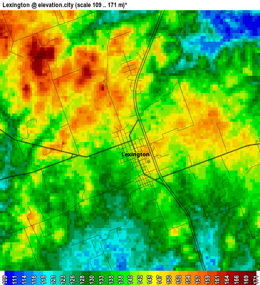
Below is the Elevation map of Lexington, which displays elevation range with different colors. Scale of the first map is from 109 to 171 m (358 to 561 ft) with average elevation of 137.9 meters (=452 ft) [note 1]
These maps also provides idea of topography and contour of this city, they are displayed at different zoom levels. More info about maps, scale and edge coordinates you can find below images.
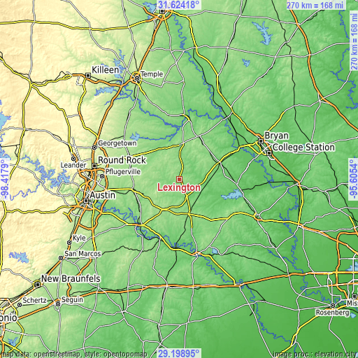
| \ | Map #1 | Topo.Map |
| Scale [m] | 109..171 m | × |
| Scale [ft] | 358..561 ft | × |
| Average | 137.9 m = 452 ft | × |
| Width | 8.43 km = 5.2 mi | 269.7 km = 167.6 mi |
| Height | 8.43 km = 5.2 mi | 269.7 km = 167.6 mi |
| ↑Max Latitude | 30.456989° | 31.62418° |
| Latitude at center | 30.4191° | 30.4191° |
| ↓Min Latitude | 30.381197° | 29.19895° |
| ← Min Longitude | -97.055595° | -98.4179° |
| Longitude center | -97.01165° | -97.01165° |
| →Max Longitude | -96.967705° | -95.6054° |
Nearby cities:
Cities around Lexington sort by population:
• Taylor elevation 176 m
41.7 km,  293°
293°
• Elgin 180 m
35.3 km,  257°
257°
• Bastrop 115 m
45 km,  220°
220°
• Camp Swift 140 m
37 km,  226°
226°
• Rockdale 146 m
26.3 km,  2°
2°
• Cameron 127 m
48.4 km, 3°
• Giddings 157 m
27.3 km,  164°
164°
• Caldwell 123 m
33 km,  67°
67°
• Smithville 104 m
47.8 km,  197°
197°
• Circle D-KC Estates 164 m
35.8 km, 216°
• Somerville 77 m
47.1 km,  99°
99°
• Thorndale 141 m
28.5 km,  319°
319°
Multilingual:
 En español:
Lexington elevación 141 m.
 En France:
Lexington élévation 141 m.
 Auf Deutsch:
Lexington höhe über dem Meeresspiegel ist 141 m.

Sources and notes:
- [note 1] Map square and city borders are not equal. Map elevation data is calculated only from area inside that square.
- [src 1] Elevation data from geonames database provided with same terms of usage.
- [src 2] The elevation map of Lexington is generated using elevation data from NASA's 3 arcsec (90m) resolution SRTM data.
- [src 3] Base (background) map © OpenStreetMap contributors tiles are generated by Geofabrik and OpenTopoMap.
Copyright & License:
This Lexington Elevation Map is licensed under CC BY-SA. You may reuse any part from this page, if you give a proper credit by linking to this URL:
 More info on terms of use page.