Smithville elevation
Smithville (Texas, Bastrop County), United States elevation is 104 meters and Smithville elevation in feet is 341 ft above sea level [src 1]. Smithville is a populated place (feature code) with elevation that is 175 meters (574 ft) smaller than average city elevation in United States.
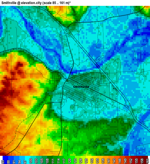
Below is the Elevation map of Smithville, which displays elevation range with different colors. Scale of the first map is from 85 to 161 m (279 to 528 ft) with average elevation of 109.3 meters (=359 ft) [note 1]
These maps also provides idea of topography and contour of this city, they are displayed at different zoom levels. More info about maps, scale and edge coordinates you can find below images.
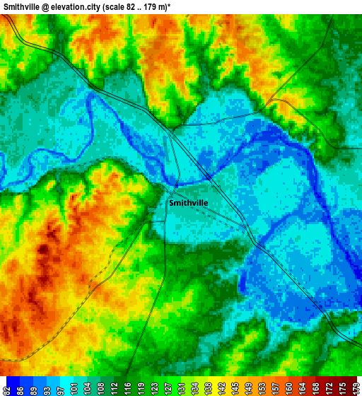
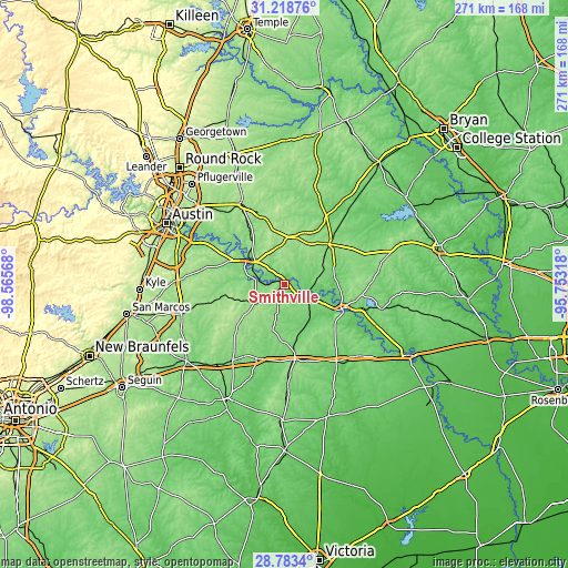
| \ | Map #1 | Map #2 | Topo.Map |
| Scale [m] | 85..161 m | 82..179 m | × |
| Scale [ft] | 279..528 ft | 269..587 ft | × |
| Average | 109.3 m = 359 ft | 119 m = 390 ft | × |
| Width | 8.46 km = 5.3 mi | 16.93 km = 10.5 mi | 270.8 km = 168.3 mi |
| Height | 8.46 km = 5.3 mi | 16.93 km = 10.5 mi | 270.8 km = 168.3 mi |
| ↑Max Latitude | 30.046597° | 30.08463° | 31.21876° |
| Latitude at center | 30.00855° | 30.00855° | 30.00855° |
| ↓Min Latitude | 29.970488° | 29.932412° | 28.7834° |
| ← Min Longitude | -97.203375° | -97.247321° | -98.56568° |
| Longitude center | -97.15943° | -97.15943° | -97.15943° |
| →Max Longitude | -97.115485° | -97.071539° | -95.75318° |
Nearby cities:
Cities around Smithville sort by population:
• Elgin elevation 180 m
43 km,  331°
331°
• Bastrop 115 m
18.8 km,  307°
307°
• Hornsby Bend 139 m
48.7 km,  303°
303°
• Camp Swift 140 m
24 km, 327°
• Giddings 157 m
28.9 km,  47°
47°
• La Grange 83 m
29.6 km,  112°
112°
• Schulenburg 114 m
43.9 km,  145°
145°
• Wyldwood 161 m
33 km,  294°
294°
• Circle D-KC Estates 164 m
18.4 km,  336°
336°
• Garfield 152 m
43.2 km, 297°
• Flatonia 142 m
36 km,  172°
172°
• Lexington 141 m
47.8 km,  17°
17°
Multilingual:
 En español:
Smithville elevación 104 m.
 En France:
Smithville élévation 104 m.
 Auf Deutsch:
Smithville höhe über dem Meeresspiegel ist 104 m.

Sources and notes:
- [note 1] Map square and city borders are not equal. Map elevation data is calculated only from area inside that square.
- [src 1] Elevation data from geonames database provided with same terms of usage.
- [src 2] The elevation map of Smithville is generated using elevation data from NASA's 3 arcsec (90m) resolution SRTM data.
- [src 3] Base (background) map © OpenStreetMap contributors tiles are generated by Geofabrik and OpenTopoMap.
Copyright & License:
This Smithville Elevation Map is licensed under CC BY-SA. You may reuse any part from this page, if you give a proper credit by linking to this URL:
 More info on terms of use page.