Garfield elevation
Garfield (Texas, Travis County), United States elevation is 152 meters and Garfield elevation in feet is 499 ft above sea level [src 1]. Garfield is a populated place (feature code) with elevation that is 127 meters (417 ft) smaller than average city elevation in United States.
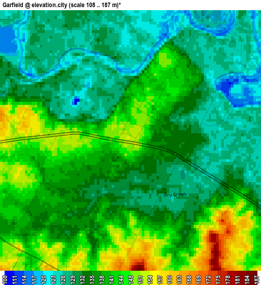
Below is the Elevation map of Garfield, which displays elevation range with different colors. Scale of the first map is from 108 to 187 m (354 to 614 ft) with average elevation of 136.4 meters (=448 ft) [note 1]
These maps also provides idea of topography and contour of this city, they are displayed at different zoom levels. More info about maps, scale and edge coordinates you can find below images.
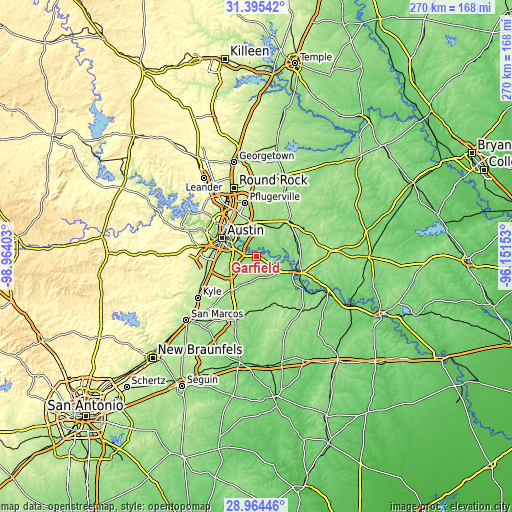
| \ | Map #1 | Topo.Map |
| Scale [m] | 108..187 m | × |
| Scale [ft] | 354..614 ft | × |
| Average | 136.4 m = 448 ft | × |
| Width | 8.45 km = 5.3 mi | 270.3 km = 168 mi |
| Height | 8.45 km = 5.3 mi | 270.3 km = 168 mi |
| ↑Max Latitude | 30.225418° | 31.39542° |
| Latitude at center | 30.18744° | 30.18744° |
| ↓Min Latitude | 30.149447° | 28.96446° |
| ← Min Longitude | -97.601725° | -98.96403° |
| Longitude center | -97.55778° | -97.55778° |
| →Max Longitude | -97.513835° | -96.15153° |
Nearby cities:
Cities around Garfield sort by population:
• Austin elevation 165 m
19.9 km,  296°
296°
• Pflugerville 224 m
28.6 km,  347°
347°
• Elgin 180 m
25.5 km,  44°
44°
• Bastrop 115 m
24.8 km,  110°
110°
• Manor 165 m
17 km,  0°
0°
• Hornsby Bend 139 m
7.1 km,  339°
339°
• Camp Swift 140 m
25.5 km,  89°
89°
• West Lake Hills 252 m
26.5 km, 297°
• Wyldwood 161 m
10.4 km,  128°
128°
• Onion Creek 184 m
22.5 km,  255°
255°
• Rollingwood 203 m
24.5 km,  293°
293°
• Manchaca 220 m
27 km, 258°
Multilingual:
 En español:
Garfield elevación 152 m.
 En France:
Garfield élévation 152 m.
 Auf Deutsch:
Garfield höhe über dem Meeresspiegel ist 152 m.

Sources and notes:
- [note 1] Map square and city borders are not equal. Map elevation data is calculated only from area inside that square.
- [src 1] Elevation data from geonames database provided with same terms of usage.
- [src 2] The elevation map of Garfield is generated using elevation data from NASA's 3 arcsec (90m) resolution SRTM data.
- [src 3] Base (background) map © OpenStreetMap contributors tiles are generated by Geofabrik and OpenTopoMap.
Copyright & License:
This Garfield Elevation Map is licensed under CC BY-SA. You may reuse any part from this page, if you give a proper credit by linking to this URL:
 More info on terms of use page.