Manor elevation
Manor (Texas, Travis County), United States elevation is 165 meters and Manor elevation in feet is 541 ft above sea level [src 1]. Manor is a populated place (feature code) with elevation that is 114 meters (374 ft) smaller than average city elevation in United States.
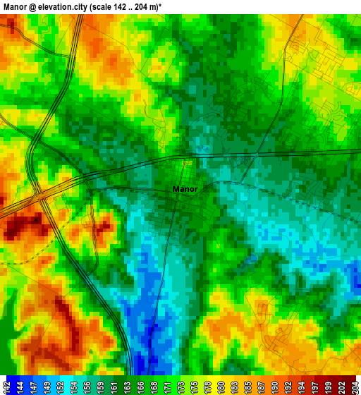
Below is the Elevation map of Manor, which displays elevation range with different colors. Scale of the first map is from 142 to 204 m (466 to 669 ft) with average elevation of 169.1 meters (=555 ft) [note 1]
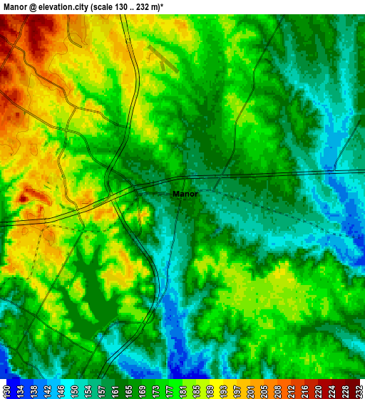
These maps also provides idea of topography and contour of this city, they are displayed at different zoom levels. More info about maps, scale and edge coordinates you can find below images.
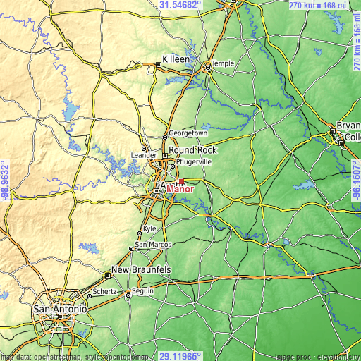
| \ | Map #1 | Map #2 | Topo.Map |
| Scale [m] | 142..204 m | 130..232 m | × |
| Scale [ft] | 466..669 ft | 427..761 ft | × |
| Average | 169.1 m = 555 ft | 172.3 m = 565 ft | × |
| Width | 8.43 km = 5.2 mi | 16.87 km = 10.5 mi | 269.9 km = 167.7 mi |
| Height | 8.43 km = 5.2 mi | 16.87 km = 10.5 mi | 269.9 km = 167.7 mi |
| ↑Max Latitude | 30.378679° | 30.416583° | 31.54682° |
| Latitude at center | 30.34076° | 30.34076° | 30.34076° |
| ↓Min Latitude | 30.302826° | 30.264878° | 29.11965° |
| ← Min Longitude | -97.600895° | -97.644841° | -98.9632° |
| Longitude center | -97.55695° | -97.55695° | -97.55695° |
| →Max Longitude | -97.513005° | -97.469059° | -96.1507° |
Nearby cities:
Cities around Manor sort by population:
• Austin elevation 165 m
19.7 km,  245°
245°
• Round Rock 226 m
22 km,  327°
327°
• Pflugerville 224 m
12.5 km, 331°
• Hutto 203 m
22.5 km,  2°
2°
• Jollyville 291 m
23.8 km,  298°
298°
• Wells Branch 256 m
16.6 km,  314°
314°
• Elgin 180 m
17.9 km,  86°
86°
• Hornsby Bend 139 m
10.7 km,  193°
193°
• West Lake Hills 252 m
24 km,  258°
258°
• Garfield 152 m
17 km,  180°
180°
• Rollingwood 203 m
23.6 km, 252°
• Windemere 234 m
15.9 km, 326°
Multilingual:
 En español:
Manor elevación 165 m.
 En France:
Manor élévation 165 m.


Sources and notes:
- [note 1] Map square and city borders are not equal. Map elevation data is calculated only from area inside that square.
- [src 1] Elevation data from geonames database provided with same terms of usage.
- [src 2] The elevation map of Manor is generated using elevation data from NASA's 3 arcsec (90m) resolution SRTM data.
- [src 3] Base (background) map © OpenStreetMap contributors tiles are generated by Geofabrik and OpenTopoMap.
Copyright & License:
This Manor Elevation Map is licensed under CC BY-SA. You may reuse any part from this page, if you give a proper credit by linking to this URL:
 More info on terms of use page.