Roanoke elevation
Roanoke (Texas, Denton County), United States elevation is 198 meters and Roanoke elevation in feet is 650 ft above sea level [src 1]. Roanoke is a populated place (feature code) with elevation that is 81 meters (266 ft) smaller than average city elevation in United States.
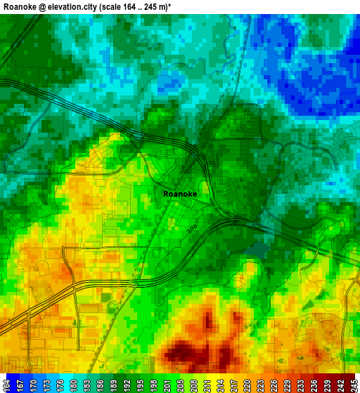
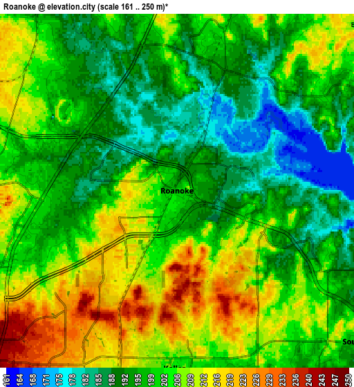
Below is the Elevation map of Roanoke, which displays elevation range with different colors. Scale of the first map is from 164 to 245 m (538 to 804 ft) with average elevation of 196.7 meters (=645 ft) [note 1]
These maps also provides idea of topography and contour of this city, they are displayed at different zoom levels. More info about maps, scale and edge coordinates you can find below images.
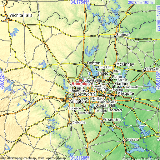
| \ | Map #1 | Map #2 | Topo.Map |
| Scale [m] | 164..245 m | 161..250 m | × |
| Scale [ft] | 538..804 ft | 528..820 ft | × |
| Average | 196.7 m = 645 ft | 200.8 m = 659 ft | × |
| Width | 8.2 km = 5.1 mi | 16.39 km = 10.2 mi | 262.2 km = 162.9 mi |
| Height | 8.2 km = 5.1 mi | 16.39 km = 10.2 mi | 262.2 km = 162.9 mi |
| ↑Max Latitude | 33.040856° | 33.077687° | 34.17541° |
| Latitude at center | 33.00401° | 33.00401° | 33.00401° |
| ↓Min Latitude | 32.967148° | 32.930271° | 31.81685° |
| ← Min Longitude | -97.269795° | -97.313741° | -98.6321° |
| Longitude center | -97.22585° | -97.22585° | -97.22585° |
| →Max Longitude | -97.181905° | -97.137959° | -95.8196° |
Nearby cities:
Cities around Roanoke sort by population:
• Flower Mound elevation 186 m
12.1 km,  84°
84°
• Keller 220 m
8.1 km,  197°
197°
• Southlake 197 m
11 km,  129°
129°
• Trophy Club 190 m
4 km,  99°
99°
• Lantana 195 m
13.5 km,  44°
44°
• Argyle 221 m
13.6 km,  16°
16°
• Justin 200 m
11.1 km,  323°
323°
• Double Oak 204 m
12.7 km,  57°
57°
• Northlake 212 m
14.2 km,  344°
344°
• Haslet 218 m
11.8 km,  254°
254°
• Bartonville 202 m
11.7 km,  48°
48°
• Westlake 206 m
3.2 km,  116°
116°
Multilingual:
 En español:
Roanoke elevación 198 m.
 En France:
Roanoke élévation 198 m.


Sources and notes:
- [note 1] Map square and city borders are not equal. Map elevation data is calculated only from area inside that square.
- [src 1] Elevation data from geonames database provided with same terms of usage.
- [src 2] The elevation map of Roanoke is generated using elevation data from NASA's 3 arcsec (90m) resolution SRTM data.
- [src 3] Base (background) map © OpenStreetMap contributors tiles are generated by Geofabrik and OpenTopoMap.
Copyright & License:
This Roanoke Elevation Map is licensed under CC BY-SA. You may reuse any part from this page, if you give a proper credit by linking to this URL:
 More info on terms of use page.