Argyle elevation
Argyle (Texas, Denton County), United States elevation is 221 meters and Argyle elevation in feet is 725 ft above sea level [src 1]. Argyle is a populated place (feature code) with elevation that is 58 meters (190 ft) smaller than average city elevation in United States.
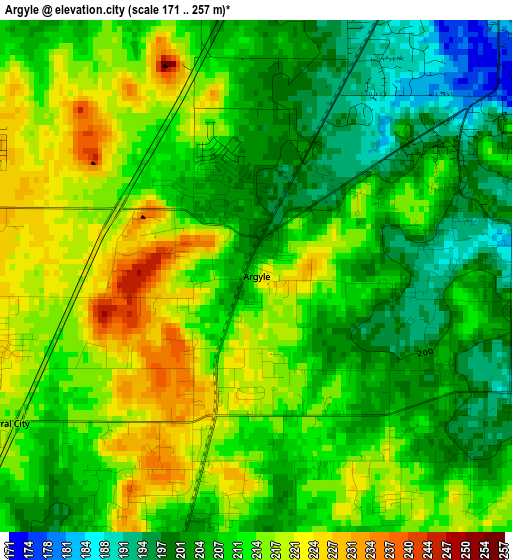
Below is the Elevation map of Argyle, which displays elevation range with different colors. Scale of the first map is from 171 to 257 m (561 to 843 ft) with average elevation of 210.1 meters (=689 ft) [note 1]
These maps also provides idea of topography and contour of this city, they are displayed at different zoom levels. More info about maps, scale and edge coordinates you can find below images.
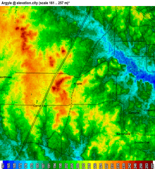
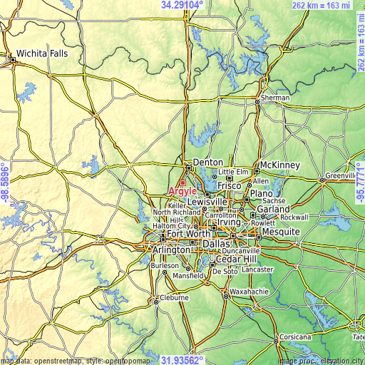
| \ | Map #1 | Map #2 | Topo.Map |
| Scale [m] | 171..257 m | 161..257 m | × |
| Scale [ft] | 561..843 ft | 528..843 ft | × |
| Average | 210.1 m = 689 ft | 203.3 m = 667 ft | × |
| Width | 8.18 km = 5.1 mi | 16.37 km = 10.2 mi | 261.9 km = 162.7 mi |
| Height | 8.18 km = 5.1 mi | 16.37 km = 10.2 mi | 261.9 km = 162.7 mi |
| ↑Max Latitude | 33.158027° | 33.194809° | 34.29104° |
| Latitude at center | 33.12123° | 33.12123° | 33.12123° |
| ↓Min Latitude | 33.084417° | 33.047589° | 31.93562° |
| ← Min Longitude | -97.227295° | -97.271241° | -98.5896° |
| Longitude center | -97.18335° | -97.18335° | -97.18335° |
| →Max Longitude | -97.139405° | -97.095459° | -95.7771° |
Nearby cities:
Cities around Argyle sort by population:
• Denton elevation 206 m
11.4 km,  24°
24°
• Corinth 190 m
11.6 km,  71°
71°
• Highland Village 174 m
13.1 km,  104°
104°
• Roanoke 198 m
13.6 km,  196°
196°
• Lantana 195 m
6.5 km,  121°
121°
• Hickory Creek 180 m
13.1 km,  89°
89°
• Justin 200 m
11.3 km,  248°
248°
• Double Oak 204 m
9.2 km,  132°
132°
• Northlake 212 m
7.7 km,  275°
275°
• Bartonville 202 m
7.2 km,  137°
137°
• Ponder 227 m
11.9 km,  305°
305°
• Copper Canyon 195 m
8.5 km,  109°
109°
Multilingual:
 En español:
Argyle elevación 221 m.
 En France:
Argyle élévation 221 m.


Sources and notes:
- [note 1] Map square and city borders are not equal. Map elevation data is calculated only from area inside that square.
- [src 1] Elevation data from geonames database provided with same terms of usage.
- [src 2] The elevation map of Argyle is generated using elevation data from NASA's 3 arcsec (90m) resolution SRTM data.
- [src 3] Base (background) map © OpenStreetMap contributors tiles are generated by Geofabrik and OpenTopoMap.
Copyright & License:
This Argyle Elevation Map is licensed under CC BY-SA. You may reuse any part from this page, if you give a proper credit by linking to this URL:
 More info on terms of use page.