Corinth elevation
Corinth (Texas, Denton County), United States elevation is 190 meters and Corinth elevation in feet is 623 ft above sea level [src 1]. Corinth is a populated place (feature code) with elevation that is 89 meters (292 ft) smaller than average city elevation in United States.
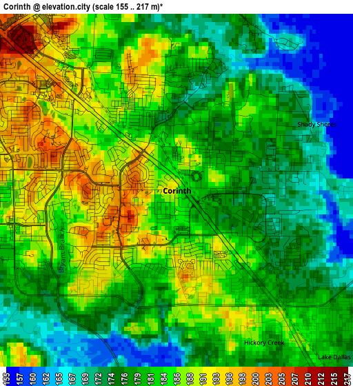
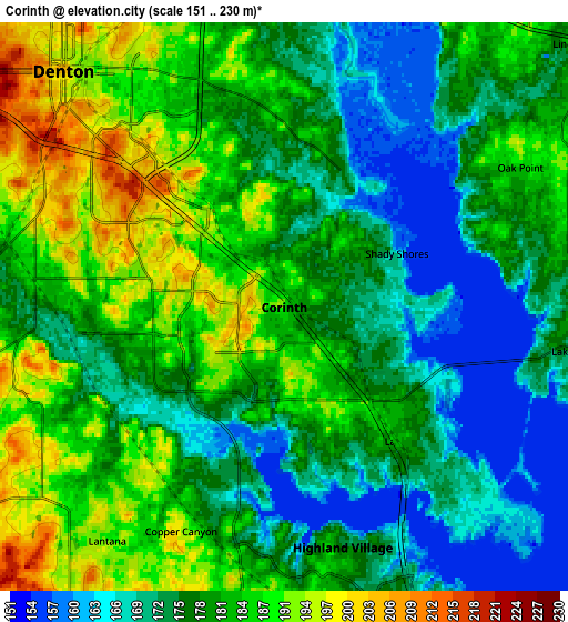
Below is the Elevation map of Corinth, which displays elevation range with different colors. Scale of the first map is from 155 to 217 m (509 to 712 ft) with average elevation of 180.8 meters (=593 ft) [note 1]
These maps also provides idea of topography and contour of this city, they are displayed at different zoom levels. More info about maps, scale and edge coordinates you can find below images.
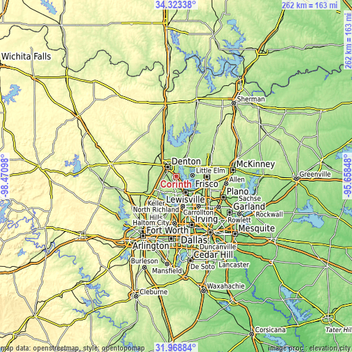
| \ | Map #1 | Map #2 | Topo.Map |
| Scale [m] | 155..217 m | 151..230 m | × |
| Scale [ft] | 509..712 ft | 495..755 ft | × |
| Average | 180.8 m = 593 ft | 179.6 m = 589 ft | × |
| Width | 8.18 km = 5.1 mi | 16.36 km = 10.2 mi | 261.8 km = 162.7 mi |
| Height | 8.18 km = 5.1 mi | 16.36 km = 10.2 mi | 261.8 km = 162.7 mi |
| ↑Max Latitude | 33.190793° | 33.227561° | 34.32338° |
| Latitude at center | 33.15401° | 33.15401° | 33.15401° |
| ↓Min Latitude | 33.117211° | 33.080397° | 31.96884° |
| ← Min Longitude | -97.108675° | -97.152621° | -98.47098° |
| Longitude center | -97.06473° | -97.06473° | -97.06473° |
| →Max Longitude | -97.020785° | -96.976839° | -95.65848° |
Nearby cities:
Cities around Corinth sort by population:
• Denton elevation 206 m
9.3 km,  316°
316°
• Little Elm 169 m
11.9 km,  85°
85°
• Highland Village 174 m
7.1 km,  166°
166°
• Lake Dallas 181 m
5.3 km,  136°
136°
• Lantana 195 m
9 km,  218°
218°
• Hickory Creek 180 m
4.1 km,  150°
150°
• Argyle 221 m
11.6 km,  251°
251°
• Oak Point 186 m
7.9 km,  59°
59°
• Double Oak 204 m
10.8 km,  203°
203°
• Shady Shores 169 m
3.5 km,  69°
69°
• Bartonville 202 m
10.9 km,  214°
214°
• Copper Canyon 195 m
7.1 km, 204°
Multilingual:
 En español:
Corinth elevación 190 m.
 En France:
Corinth élévation 190 m.


Sources and notes:
- [note 1] Map square and city borders are not equal. Map elevation data is calculated only from area inside that square.
- [src 1] Elevation data from geonames database provided with same terms of usage.
- [src 2] The elevation map of Corinth is generated using elevation data from NASA's 3 arcsec (90m) resolution SRTM data.
- [src 3] Base (background) map © OpenStreetMap contributors tiles are generated by Geofabrik and OpenTopoMap.
Copyright & License:
This Corinth Elevation Map is licensed under CC BY-SA. You may reuse any part from this page, if you give a proper credit by linking to this URL:
 More info on terms of use page.