Northlake elevation
Northlake (Texas, Denton County), United States elevation is 212 meters and Northlake elevation in feet is 696 ft above sea level [src 1]. Northlake is a populated place (feature code) with elevation that is 67 meters (220 ft) smaller than average city elevation in United States.
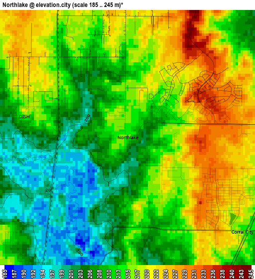
Below is the Elevation map of Northlake, which displays elevation range with different colors. Scale of the first map is from 185 to 245 m (607 to 804 ft) with average elevation of 213.1 meters (=699 ft) [note 1]
These maps also provides idea of topography and contour of this city, they are displayed at different zoom levels. More info about maps, scale and edge coordinates you can find below images.
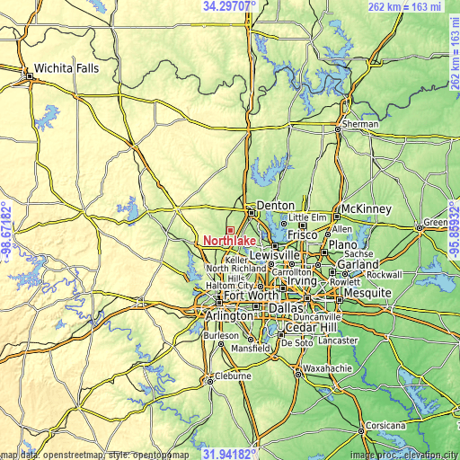
| \ | Map #1 | Topo.Map |
| Scale [m] | 185..245 m | × |
| Scale [ft] | 607..804 ft | × |
| Average | 213.1 m = 699 ft | × |
| Width | 8.18 km = 5.1 mi | 261.9 km = 162.7 mi |
| Height | 8.18 km = 5.1 mi | 261.9 km = 162.7 mi |
| ↑Max Latitude | 33.164135° | 34.29707° |
| Latitude at center | 33.12734° | 33.12734° |
| ↓Min Latitude | 33.09053° | 31.94182° |
| ← Min Longitude | -97.309515° | -98.67182° |
| Longitude center | -97.26557° | -97.26557° |
| →Max Longitude | -97.221625° | -95.85932° |
Nearby cities:
Cities around Northlake sort by population:
• Denton elevation 206 m
15.7 km,  51°
51°
• Trophy Club 190 m
16.3 km,  152°
152°
• Roanoke 198 m
14.2 km,  164°
164°
• Lantana 195 m
13.8 km,  107°
107°
• Krum 229 m
15.1 km,  9°
9°
• Argyle 221 m
7.7 km,  95°
95°
• Justin 200 m
5.5 km,  211°
211°
• Double Oak 204 m
16 km,  115°
115°
• Bartonville 202 m
13.8 km, 115°
• Ponder 227 m
6.5 km,  341°
341°
• Copper Canyon 195 m
16.1 km, 102°
• Westlake 206 m
16.5 km, 156°
Multilingual:
 En español:
Northlake elevación 212 m.
 En France:
Northlake élévation 212 m.
 Auf Deutsch:
Northlake höhe über dem Meeresspiegel ist 212 m.

Sources and notes:
- [note 1] Map square and city borders are not equal. Map elevation data is calculated only from area inside that square.
- [src 1] Elevation data from geonames database provided with same terms of usage.
- [src 2] The elevation map of Northlake is generated using elevation data from NASA's 3 arcsec (90m) resolution SRTM data.
- [src 3] Base (background) map © OpenStreetMap contributors tiles are generated by Geofabrik and OpenTopoMap.
Copyright & License:
This Northlake Elevation Map is licensed under CC BY-SA. You may reuse any part from this page, if you give a proper credit by linking to this URL:
 More info on terms of use page.