Nixon elevation
Nixon (Texas, Gonzales County), United States elevation is 124 meters and Nixon elevation in feet is 407 ft above sea level [src 1]. Nixon is a populated place (feature code) with elevation that is 155 meters (509 ft) smaller than average city elevation in United States.
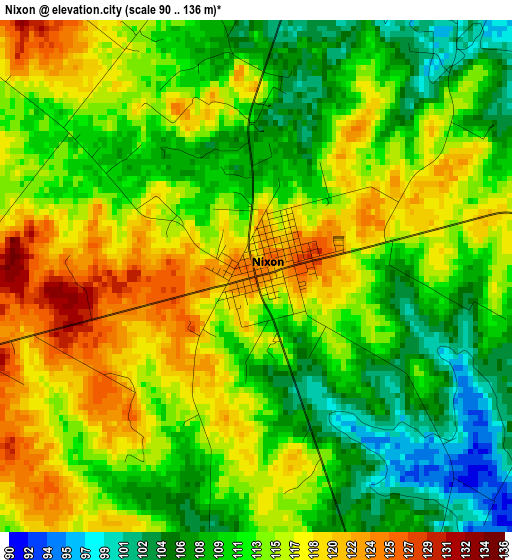
Below is the Elevation map of Nixon, which displays elevation range with different colors. Scale of the first map is from 90 to 136 m (295 to 446 ft) with average elevation of 113 meters (=371 ft) [note 1]
These maps also provides idea of topography and contour of this city, they are displayed at different zoom levels. More info about maps, scale and edge coordinates you can find below images.
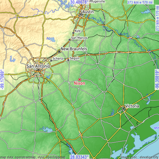
| \ | Map #1 | Topo.Map |
| Scale [m] | 90..136 m | × |
| Scale [ft] | 295..446 ft | × |
| Average | 113 m = 371 ft | × |
| Width | 8.52 km = 5.3 mi | 272.8 km = 169.5 mi |
| Height | 8.53 km = 5.3 mi | 272.8 km = 169.5 mi |
| ↑Max Latitude | 29.305788° | 30.48678° |
| Latitude at center | 29.26746° | 29.26746° |
| ↓Min Latitude | 29.229117° | 28.03343° |
| ← Min Longitude | -97.808385° | -99.17069° |
| Longitude center | -97.76444° | -97.76444° |
| →Max Longitude | -97.720495° | -96.35819° |
Nearby cities:
Cities around Nixon sort by population:
• Seguin elevation 165 m
38.7 km,  329°
329°
• Gonzales 94 m
39.9 km,  49°
49°
• Floresville 124 m
40.8 km,  248°
248°
• Luling 129 m
47.3 km,  13°
13°
• Karnes City 133 m
44.5 km,  197°
197°
• McQueeney 169 m
44.5 km,  324°
324°
• Poth 125 m
37.9 km,  234°
234°
• Yorktown 87 m
40.7 km,  141°
141°
• Saint Hedwig 181 m
45.3 km,  291°
291°
• Stockdale 138 m
19.3 km,  259°
259°
• La Vernia 153 m
35.4 km, 286°
• Runge 97 m
43 km,  173°
173°
Multilingual:
 En español:
Nixon elevación 124 m.
 En France:
Nixon élévation 124 m.


Sources and notes:
- [note 1] Map square and city borders are not equal. Map elevation data is calculated only from area inside that square.
- [src 1] Elevation data from geonames database provided with same terms of usage.
- [src 2] The elevation map of Nixon is generated using elevation data from NASA's 3 arcsec (90m) resolution SRTM data.
- [src 3] Base (background) map © OpenStreetMap contributors tiles are generated by Geofabrik and OpenTopoMap.
Copyright & License:
This Nixon Elevation Map is licensed under CC BY-SA. You may reuse any part from this page, if you give a proper credit by linking to this URL:
 More info on terms of use page.