La Vernia elevation
La Vernia (Texas, Wilson County), United States elevation is 153 meters and La Vernia elevation in feet is 502 ft above sea level [src 1]. La Vernia is a populated place (feature code) with elevation that is 126 meters (413 ft) smaller than average city elevation in United States.
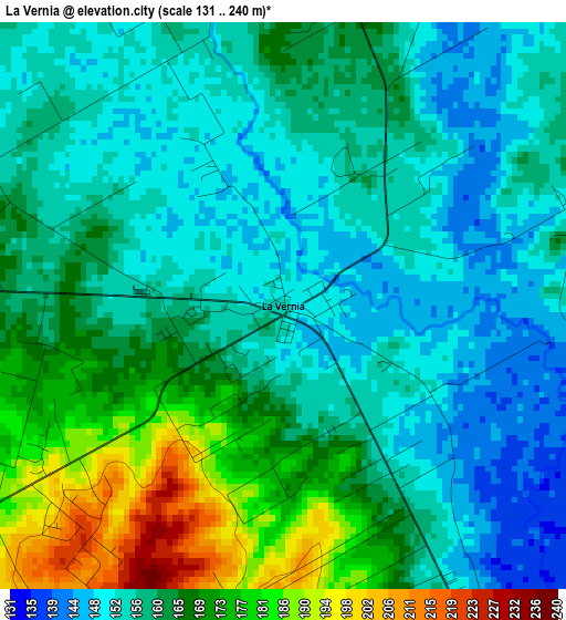
Below is the Elevation map of La Vernia, which displays elevation range with different colors. Scale of the first map is from 131 to 240 m (430 to 787 ft) with average elevation of 160.9 meters (=528 ft) [note 1]
These maps also provides idea of topography and contour of this city, they are displayed at different zoom levels. More info about maps, scale and edge coordinates you can find below images.
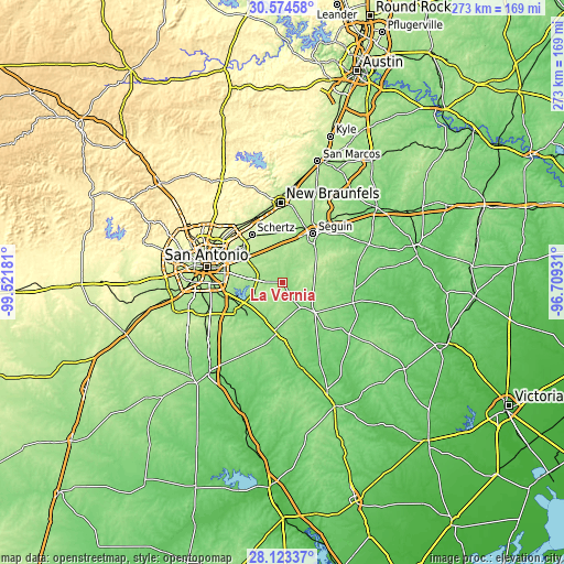
| \ | Map #1 | Topo.Map |
| Scale [m] | 131..240 m | × |
| Scale [ft] | 430..787 ft | × |
| Average | 160.9 m = 528 ft | × |
| Width | 8.52 km = 5.3 mi | 272.5 km = 169.3 mi |
| Height | 8.52 km = 5.3 mi | 272.6 km = 169.4 mi |
| ↑Max Latitude | 29.394645° | 30.57458° |
| Latitude at center | 29.35635° | 29.35635° |
| ↓Min Latitude | 29.318041° | 28.12337° |
| ← Min Longitude | -98.159505° | -99.52181° |
| Longitude center | -98.11556° | -98.11556° |
| →Max Longitude | -98.071615° | -96.70931° |
Nearby cities:
Cities around La Vernia sort by population:
• Schertz elevation 220 m
26.4 km,  325°
325°
• Seguin 165 m
27.8 km,  31°
31°
• Cibolo 217 m
25.2 km, 334°
• Converse 222 m
26.5 km,  312°
312°
• Universal City 236 m
27.3 km,  321°
321°
• Floresville 124 m
25.1 km,  189°
189°
• McQueeney 169 m
27.4 km,  16°
16°
• Saint Hedwig 181 m
10.4 km, 308°
• Elmendorf 155 m
23.8 km,  242°
242°
• Stockdale 138 m
20.1 km,  131°
131°
• China Grove 205 m
22.9 km,  279°
279°
• Marion 199 m
24 km,  354°
354°
Multilingual:
 En español:
La Vernia elevación 153 m.
 En France:
La Vernia élévation 153 m.
 Auf Deutsch:
La Vernia höhe über dem Meeresspiegel ist 153 m.

Sources and notes:
- [note 1] Map square and city borders are not equal. Map elevation data is calculated only from area inside that square.
- [src 1] Elevation data from geonames database provided with same terms of usage.
- [src 2] The elevation map of La Vernia is generated using elevation data from NASA's 3 arcsec (90m) resolution SRTM data.
- [src 3] Base (background) map © OpenStreetMap contributors tiles are generated by Geofabrik and OpenTopoMap.
Copyright & License:
This La Vernia Elevation Map is licensed under CC BY-SA. You may reuse any part from this page, if you give a proper credit by linking to this URL:
 More info on terms of use page.